
Topografische kaart Gulf Shores
Interactieve kaart
Klik op de kaart om de hoogte weer te geven.
Over deze kaart
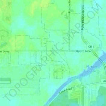
Naam: Topografische kaart Gulf Shores, hoogte, reliëf.
Gemiddelde hoogte: 6 m
Minimale hoogte: 0 m
Maximale hoogte: 12 m
Jack Edwards National Airport is located in Gulf Shores and offers services from Gulf Air Center, Salt Air Aviation Center and Platium Air Center. The airport is located in town, two miles from the beach. Their FBO Gulf Air Center will provide a rental vehicle while they take care of fueling and storing aircraft. There is 48-hour and long term parking available. The longest paved runway extends 6,962 feet. The facility is at an elevation of 17 feet. They offer outside tiedown as well as hangar space for aircraft. They can provide space by the night, week or month.
Andere topografische kaarten
Klik op een kaart om zijn topografie, zijn hoogte en zijn reliëf te bekijken.
Gulf Shores
United States of America > Alabama > Gulf Shores
Gulf Shores, Baldwin County, Alabama, United States of America
Gemiddelde hoogte: 5 m