
Topografische kaart McKenzie River
Interactieve kaart
Klik op de kaart om de hoogte weer te geven.
Over deze kaart
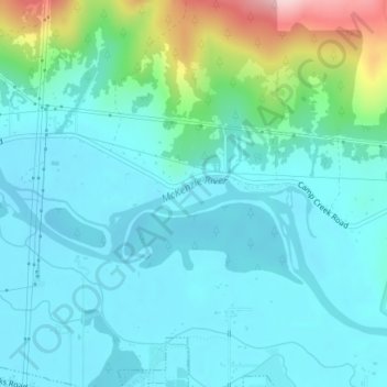
Naam: Topografische kaart McKenzie River, hoogte, reliëf.
Gemiddelde hoogte: 190 m
Minimale hoogte: 143 m
Maximale hoogte: 389 m
The McKenzie River drains a region of about 1,300 square miles (3,400 km2) and is one of the primary tributaries of the Willamette River. Elevations in the watershed range from 10,358 feet (3,157 m) at the summit of the South Sister to 375 feet (114 m) at the McKenzie's mouth on the Willamette River north of Eugene. The upper basin, in the high Cascades, consists of granular, permeable igneous rocks that are geologically young, while most of the middle and lower McKenzie valley in the Western Cascades is made of the remnants of older, more weathered volcanic rocks. Major watersheds bordering the McKenzie basin include the Calapooia; the South, Middle and North Santiam rivers to the north; the Middle Fork Willamette River to the south; and the Deschutes River to the east.
Andere topografische kaarten
Klik op een kaart om zijn topografie, zijn hoogte en zijn reliëf te bekijken.
Redmond
United States of America > Oregon > Redmond
Redmond, Deschutes County, Oregon, 97756, United States of America
Gemiddelde hoogte: 919 m
Tualatin River
United States of America > Oregon
Tualatin River, Clackamas County, Oregon, 97068, United States of America
Gemiddelde hoogte: 82 m
Forfar
United States of America > Oregon > Forfar
Forfar, Lincoln County, Oregon, United States of America
Gemiddelde hoogte: 30 m
Wimer
United States of America > Oregon > Wimer
Wimer, Jackson County, Oregon, United States of America
Gemiddelde hoogte: 417 m
Trask River
United States of America > Oregon
Trask River, Tillamook County, Oregon, 97141, United States of America
Gemiddelde hoogte: 223 m
Springwater
United States of America > Oregon > Springwater
Springwater, Clackamas County, Oregon, 97023, United States of America
Gemiddelde hoogte: 309 m
Millican
United States of America > Oregon > Millican
Millican, Deschutes County, Oregon, United States of America
Gemiddelde hoogte: 1.337 m
Brickerville
United States of America > Oregon > Mapleton > Brickerville
Brickerville, Mapleton, Lane County, Oregon, 97453, United States of America
Gemiddelde hoogte: 183 m
Tillamook Rock Light
United States of America > Oregon
Tillamook Rock Light, Tillamook Rock Lighthouse Trail, Clatsop County, Oregon, United States of America
Gemiddelde hoogte: 0 m
Oak Grove
United States of America > Oregon > Oak Grove
Oak Grove, Clackamas County, Oregon, 97268, United States of America
Gemiddelde hoogte: 49 m
Saum Creek
United States of America > Oregon
Saum Creek, Washington County, Oregon, 97062, United States of America
Gemiddelde hoogte: 110 m
Pilot Rock
United States of America > Oregon > Pilot Rock
Pilot Rock, Umatilla County, Oregon, United States of America
Gemiddelde hoogte: 527 m
Hail Creek
United States of America > Oregon
Hail Creek, Crook County, Oregon, United States of America
Gemiddelde hoogte: 1.412 m
Thousand Springs
United States of America > Oregon
Thousand Springs, Thousand Springs Road, Jackson County, Oregon, United States of America
Gemiddelde hoogte: 1.536 m
Saint Joseph
United States of America > Oregon > Saint Joseph
Saint Joseph, Yamhill County, Oregon, 97127, United States of America
Gemiddelde hoogte: 44 m
Jones Creek
United States of America > Oregon
Jones Creek, Josephine County, Oregon, 97506, United States of America
Gemiddelde hoogte: 333 m