
Doe een donatie
Rust jezelf uit voor je volgende avontuur:
Als Amazon-partner verdient deze site een commissie op in aanmerking komende aankopen, zonder extra kosten voor jou.
Topografische kaart Star
Klik op de kaart om de hoogte weer te geven.
Doe een donatie
Rust jezelf uit voor je volgende avontuur:
Als Amazon-partner verdient deze site een commissie op in aanmerking komende aankopen, zonder extra kosten voor jou.
Star
Star is located at 43°41′39″N 116°29′25″W / 43.69417°N 116.49028°W / 43.69417; -116.49028 (43.694084, -116.490225), at an elevation of 2,470 feet (753 m) above sea level. According to the United States Census Bureau, the city has a total area of 5.86 square miles (15.18 km2), of which 5.82 square miles (15.07 km2) is land and 0.04 square miles (0.10 km2) is water.
Doe een donatie
Rust jezelf uit voor je volgende avontuur:
Als Amazon-partner verdient deze site een commissie op in aanmerking komende aankopen, zonder extra kosten voor jou.
Over deze kaart
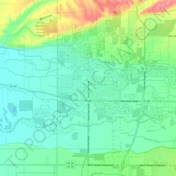
Naam: Topografische kaart Star, hoogte, reliëf.
Locatie: Star, Ada County, Idaho, 83669, United States (43.66303 -116.55282 43.73215 -116.44344)
Gemiddelde hoogte: 765 m
Minimale hoogte: 737 m
Maximale hoogte: 840 m
Doe een donatie
Rust jezelf uit voor je volgende avontuur:
Als Amazon-partner verdient deze site een commissie op in aanmerking komende aankopen, zonder extra kosten voor jou.
Andere topografische kaarten
Klik op een kaart om zijn topografie, zijn hoogte en zijn reliëf te bekijken.
Boise
United States > Idaho > Ada County
Boise (locally /ˈbɔɪsi/ BOY-see) is the capital and most populous city of the U.S. state of Idaho and is the county seat of Ada County. As of the 2020 census, there were 235,684 people residing in the city. On the Boise River in southwestern Idaho, it is 41 miles (66 km) east of the Oregon border and 110…
Gemiddelde hoogte: 1.040 m
Doe een donatie
Rust jezelf uit voor je volgende avontuur:
Als Amazon-partner verdient deze site een commissie op in aanmerking komende aankopen, zonder extra kosten voor jou.