
Topografische kaart Château-Renault
Interactieve kaart
Klik op de kaart om de hoogte weer te geven.
Château-Renault
Château-Renault is located on the Far-West of the Gâtine Tourangelle plateau, next to the Loir-et-Cher department and at the confluence of two rivers : The Gault and the Brenne. Its Elevation vary between 90 meters and 140 meters on the plateau. The area of the commune is 3.51 square kilometre.
Over deze kaart
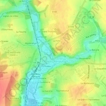
Naam: Topografische kaart Château-Renault, hoogte, reliëf.
Gemiddelde hoogte: 112 m
Minimale hoogte: 83 m
Maximale hoogte: 141 m