
Topografische kaart Gordon/Barrie Island
Interactieve kaart
Klik op de kaart om de hoogte weer te geven.
Over deze kaart
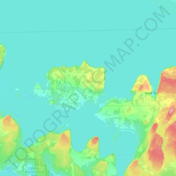
Naam: Topografische kaart Gordon/Barrie Island, hoogte, reliëf.
Gemiddelde hoogte: 187 m
Minimale hoogte: 171 m
Maximale hoogte: 284 m
Andere topografische kaarten
Klik op een kaart om zijn topografie, zijn hoogte en zijn reliëf te bekijken.
Manitoulin Island
Canada > Ontario > Manitoulin District
Manitoulin Island, Manitoulin District, Northeastern Ontario, Ontario, Canada
Gemiddelde hoogte: 194 m
Rabbit Island
Canada > Ontario > Manitoulin District > Northeastern Manitoulin and the Islands
Rabbit Island, Northeastern Manitoulin and the Islands, Manitoulin District, Northeastern Ontario, Ontario, Canada
Gemiddelde hoogte: 187 m
Gibraltar
Canada > Ontario > Manitoulin District > Central Manitoulin
Gibraltar, Central Manitoulin, Manitoulin District, Northeastern Ontario, Ontario, Canada
Gemiddelde hoogte: 240 m
Burpee and Mills Township
Canada > Ontario > Manitoulin District
Burpee and Mills Township, Manitoulin District, Northeastern Ontario, Ontario, Canada
Gemiddelde hoogte: 188 m
Providence Bay
Canada > Ontario > Manitoulin District > Central Manitoulin
Providence Bay, Central Manitoulin, Manitoulin District, Northeastern Ontario, Ontario, P0P 1T0, Canada
Gemiddelde hoogte: 180 m
Assiginack Township
Canada > Ontario > Manitoulin District
Assiginack Township, Manitoulin District, Northeastern Ontario, Ontario, P0P 1N0, Canada
Gemiddelde hoogte: 207 m
Sheguiandah
Canada > Ontario > Manitoulin District
Sheguiandah, Manitoulin District, Northeastern Ontario, Ontario, P0P 1W0, Canada
Gemiddelde hoogte: 217 m
Little Current
Canada > Ontario > Manitoulin District > Northeastern Manitoulin and the Islands
Little Current, Northeastern Manitoulin and the Islands, Manitoulin District, Northeastern Ontario, Ontario, P0P 1K0, Canada
Gemiddelde hoogte: 193 m
Silver Water
Canada > Ontario > Manitoulin District > Unorganized West Manitoulin
Silver Water, Unorganized West Manitoulin, Manitoulin District, Northeastern Ontario, Ontario, Canada
Gemiddelde hoogte: 226 m
Evansville
Canada > Ontario > Manitoulin District > Burpee and Mills Township
Evansville, Burpee and Mills Township, Manitoulin District, Northeastern Ontario, Ontario, Canada
Gemiddelde hoogte: 193 m
McKenzie Island
Canada > Ontario > Manitoulin District > Northeastern Manitoulin and the Islands
McKenzie Island, Northeastern Manitoulin and the Islands, Manitoulin District, Northeastern Ontario, Ontario, Canada
Gemiddelde hoogte: 210 m
Meldrum Bay
Canada > Ontario > Manitoulin District > Unorganized West Manitoulin
Meldrum Bay, Unorganized West Manitoulin, Manitoulin District, Northeastern Ontario, Ontario, Canada
Gemiddelde hoogte: 176 m
Gore Bay
Canada > Ontario > Manitoulin District
Gore Bay, Manitoulin District, Northeastern Ontario, Ontario, P0P 1H0, Canada
Gemiddelde hoogte: 211 m
Kagawong
Canada > Ontario > Manitoulin District > Billings Township
Kagawong, Billings Township, Manitoulin District, Northeastern Ontario, Ontario, P0P 1J0, Canada
Gemiddelde hoogte: 206 m
Northeastern Manitoulin and the Islands
Canada > Ontario > Manitoulin District
Northeastern Manitoulin and the Islands, Manitoulin District, Northeastern Ontario, Ontario, Canada
Gemiddelde hoogte: 192 m
Mindemoya
Canada > Ontario > Manitoulin District > Central Manitoulin
Mindemoya, Central Manitoulin, Manitoulin District, Northeastern Ontario, Ontario, P0P 1S0, Canada
Gemiddelde hoogte: 220 m