
Topografische kaart Castel Gandolfo
Interactieve kaart
Klik op de kaart om de hoogte weer te geven.
Castel Gandolfo
The maximum elevation registered in the territory is 425 metres (1,394 ft) above sea level, at the Collegio di Propaganda Fide adjoining Villa Barberini. On the crown of the hills around the Lake Albano, the elevation is only 400 metres (1,300 ft) above sea level, at the summit of Monte Cucco, bordering Marino.
Over deze kaart
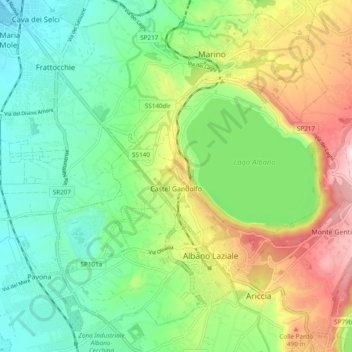
Naam: Topografische kaart Castel Gandolfo, hoogte, reliëf.
Locatie: Castel Gandolfo, Roma Capitale, 00073, Italy (41.72476 12.59258 41.76520 12.68832)
Gemiddelde hoogte: 306 m
Minimale hoogte: 131 m
Maximale hoogte: 633 m