
Topografische kaart Great Branch
Interactieve kaart
Klik op de kaart om de hoogte weer te geven.
Over deze kaart
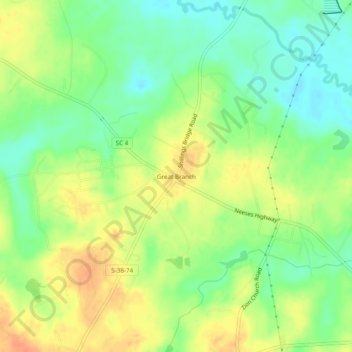
Naam: Topografische kaart Great Branch, hoogte, reliëf.
Gemiddelde hoogte: 68 m
Minimale hoogte: 47 m
Maximale hoogte: 90 m
Andere topografische kaarten
Klik op een kaart om zijn topografie, zijn hoogte en zijn reliëf te bekijken.
Santee State Park
United States > South Carolina > Orangeburg County
Santee State Park, Orangeburg County, South Carolina, United States
Gemiddelde hoogte: 35 m
Cordova
United States > South Carolina > Orangeburg County
Cordova, Orangeburg County, South Carolina, 26039, United States
Gemiddelde hoogte: 70 m
Lake Marion
United States > South Carolina > Orangeburg County
Lake Marion, Orangeburg County, South Carolina, United States
Gemiddelde hoogte: 38 m
Orangeburg
United States > South Carolina > Orangeburg County
Orangeburg, Orangeburg County, South Carolina, 29115, United States
Gemiddelde hoogte: 64 m
Forest Lake Estates
United States > South Carolina > Orangeburg County
Forest Lake Estates, Orangeburg County, South Carolina, 29118, United States
Gemiddelde hoogte: 76 m
Edisto
United States > South Carolina > Orangeburg County
Edisto, Orangeburg County, South Carolina, United States
Gemiddelde hoogte: 61 m
Springfield
United States > South Carolina > Orangeburg County > Springfield
Springfield, Orangeburg County, South Carolina, United States
Gemiddelde hoogte: 84 m
Norway
United States > South Carolina > Orangeburg County > Norway > Norway
Norway, Orangeburg County, South Carolina, 29113, United States
Gemiddelde hoogte: 73 m
Eutawville
United States > South Carolina > Orangeburg County
Eutawville, Orangeburg County, South Carolina, United States
Gemiddelde hoogte: 34 m
Berry Woods
United States > South Carolina > Orangeburg County > Orangeburg
Berry Woods, Orangeburg, Orangeburg County, South Carolina, 29115, United States
Gemiddelde hoogte: 70 m
Eutaw Springs
United States > South Carolina > Orangeburg County
Eutaw Springs, Orangeburg County, South Carolina, 29048, United States
Gemiddelde hoogte: 27 m