
Topografische kaart Waterton Park
Interactieve kaart
Klik op de kaart om de hoogte weer te geven.
Over deze kaart
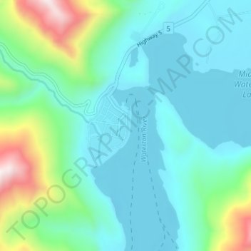
Naam: Topografische kaart Waterton Park, hoogte, reliëf.
Gemiddelde hoogte: 1.456 m
Minimale hoogte: 1.269 m
Maximale hoogte: 2.207 m
It is located at the southwestern terminus of Highway 5, approximately 54 kilometres (34 mi) west of the Town of Cardston and 55 kilometres (34 mi) south of the Town of Pincher Creek. This hamlet is north of Glacier National Park in Montana. It has an elevation of 1,280 metres (4,200 ft).
Andere topografische kaarten
Klik op een kaart om zijn topografie, zijn hoogte en zijn reliëf te bekijken.
Waterton Lakes National Park
Canada > Alberta > Improvement District No. 04
Waterton Lakes National Park, Improvement District No. 04, Alberta, T0K 2M0, Canada
Gemiddelde hoogte: 1.778 m
Mount Blakiston
Canada > Alberta > Improvement District No. 04
Mount Blakiston, Improvement District No. 04, Alberta, Canada
Gemiddelde hoogte: 2.328 m