
Doe een donatie
Rust jezelf uit voor je volgende avontuur:
Als Amazon-partner verdient deze site een commissie op in aanmerking komende aankopen, zonder extra kosten voor jou.
Topografische kaart Mawson Peak
Klik op de kaart om de hoogte weer te geven.
Doe een donatie
Rust jezelf uit voor je volgende avontuur:
Als Amazon-partner verdient deze site een commissie op in aanmerking komende aankopen, zonder extra kosten voor jou.
Mawson Peak
With an elevation of 2,745 metres (9,006 ft), it is the third highest peak in any state, territory or claimed territory of Australia, higher than the 2,228-metre (7,310 ft) Mount Kosciuszko, and surpassed only by the 3,490-metre (11,450 ft) Mount McClintock and the 3,355-metre (11,007 ft) Mount Menzies in the Australian Antarctic Territory. The Australian Antarctic Territory is a territorial claim unrecognised by most other countries, meaning that Mawson Peak is the highest mountain over which Australia has true sovereignty. The peak erupts fairly frequently, and as recently as May 2023. Mawson Peak is ranked the 30th of Earth's most topographically isolated summits.
Doe een donatie
Rust jezelf uit voor je volgende avontuur:
Als Amazon-partner verdient deze site een commissie op in aanmerking komende aankopen, zonder extra kosten voor jou.
Over deze kaart
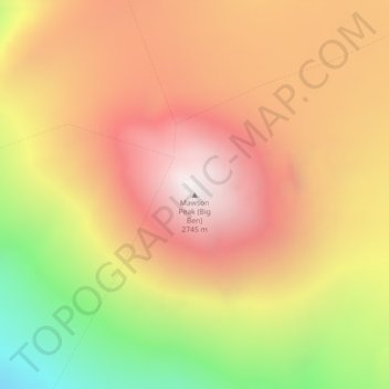
Naam: Topografische kaart Mawson Peak, hoogte, reliëf.
Locatie: Mawson Peak, Heard Island and McDonald Islands, Australia (-53.10429 73.51662 -53.10419 73.51672)
Gemiddelde hoogte: 2.175 m
Minimale hoogte: 1.386 m
Maximale hoogte: 2.738 m
Doe een donatie
Rust jezelf uit voor je volgende avontuur:
Als Amazon-partner verdient deze site een commissie op in aanmerking komende aankopen, zonder extra kosten voor jou.
Andere topografische kaarten
Klik op een kaart om zijn topografie, zijn hoogte en zijn reliëf te bekijken.
Sydney
Sydney's topography is characterized by a diverse landscape that seamlessly blends coastal features with inland plateaus. The city is divided into two primary regions: the relatively flat Cumberland Plain to the south and west of Sydney Harbour, and the elevated Hornsby Plateau to the north. The Cumberland…
Gemiddelde hoogte: 53 m
City of Melbourne
Melbourne's topography is characterized by a diverse landscape that transitions from flat coastal plains to rolling hills and mountainous regions. The city is situated at the northern end of Port Phillip Bay, where the terrain is predominantly flat, facilitating urban development. As one moves eastward, the…
Gemiddelde hoogte: 18 m
Victoria
Victoria, Australia, exhibits a remarkably varied topography shaped by the Great Dividing Range, which forms a west-to-east spine across the state. In the northeast, the Victorian Alps rise to the state’s highest point, Mount Bogong at 1,986 meters, amid deep valleys and snow-capped ridges, while westward,…
Gemiddelde hoogte: 179 m
New South Wales
New South Wales (NSW), located on Australia's eastern seaboard, boasts a diverse topography that significantly influences its landscapes and ecosystems. The state's eastern edge is dominated by a narrow coastal plain, featuring regions such as the Illawarra and Shoalhaven near Nowra, characterized by rolling…
Gemiddelde hoogte: 154 m
Doe een donatie
Rust jezelf uit voor je volgende avontuur:
Als Amazon-partner verdient deze site een commissie op in aanmerking komende aankopen, zonder extra kosten voor jou.
Queensland
Queensland's topography is characterized by a diverse landscape that includes coastal plains, mountain ranges, plateaus, and expansive inland areas. The Great Dividing Range runs parallel to the state's eastern coast, forming a series of mountain ranges, plateaus, and upland areas. This range influences the…
Gemiddelde hoogte: 122 m
New South Wales
New South Wales (NSW), located on Australia's eastern seaboard, boasts a diverse topography that significantly influences its landscapes and ecosystems. The state's eastern edge is dominated by a narrow coastal plain, featuring regions such as the Illawarra and Shoalhaven near Nowra, characterized by rolling…
Gemiddelde hoogte: 154 m
Melbourne
Melbourne is also prone to isolated convective showers forming when a cold pool crosses the state, especially if there is considerable daytime heating. These showers are often heavy and can include hail, squalls, and significant drops in temperature, but they often pass through very quickly with a rapid…
Gemiddelde hoogte: 185 m
Doe een donatie
Rust jezelf uit voor je volgende avontuur:
Als Amazon-partner verdient deze site een commissie op in aanmerking komende aankopen, zonder extra kosten voor jou.
Tasmania
The most mountainous region is the Central Highlands area, which covers most of the central western parts of the state. The Midlands located in the central east, is fairly flat, and is predominantly used for agriculture, although farming activity is scattered throughout the state. Tasmania's tallest mountain…
Gemiddelde hoogte: 220 m
Great Dividing Range
The Great Dividing Range, also known as the East Australian Cordillera or the Eastern Highlands, is a cordillera system in eastern Australia consisting of an expansive collection of mountain ranges, plateaus and rolling hills, that runs roughly parallel to the east coast of Australia and forms the…
Gemiddelde hoogte: 117 m
Western Australia
Because the only mountain-building since then has been of the Stirling Range with the rifting from Antarctica, the land is extremely eroded and ancient, with no part of the state above 1,245 metres (4,085 ft) AHD (at Mount Meharry in the Hamersley Range of the Pilbara region). Most of the state is a low…
Gemiddelde hoogte: 194 m
Doe een donatie
Rust jezelf uit voor je volgende avontuur:
Als Amazon-partner verdient deze site een commissie op in aanmerking komende aankopen, zonder extra kosten voor jou.
City of Brisbane
Brisbane's topography is characterized by a series of hills and ranges that define its landscape. The city is situated on a low-lying floodplain, with the Brisbane River meandering through its heart, creating a winding course with many steep curves from the southwest to its mouth at Moreton Bay in the east.…
Gemiddelde hoogte: 71 m
Melbourne
Melbourne is also prone to isolated convective showers forming when a cold pool crosses the state, especially if there is considerable daytime heating. These showers are often heavy and can include hail, squalls, and significant drops in temperature, but they often pass through very quickly with a rapid…
Gemiddelde hoogte: 185 m
Doe een donatie
Rust jezelf uit voor je volgende avontuur:
Als Amazon-partner verdient deze site een commissie op in aanmerking komende aankopen, zonder extra kosten voor jou.
Doe een donatie
Rust jezelf uit voor je volgende avontuur:
Als Amazon-partner verdient deze site een commissie op in aanmerking komende aankopen, zonder extra kosten voor jou.
Adelaide
Australia > South Australia > Adelaide City Council
South Australia was officially established as a British Province in England in February 1836. The first governor proclaimed the commencement of colonial government in South Australia on 28 December 1836, near The Old Gum Tree in what is now the suburb of Glenelg North. The event is commemorated in South…
Gemiddelde hoogte: 146 m
Doe een donatie
Rust jezelf uit voor je volgende avontuur:
Als Amazon-partner verdient deze site een commissie op in aanmerking komende aankopen, zonder extra kosten voor jou.
Lord Howe Island
Australia > New South Wales > Unincorporated New South Wales > Lord Howe Island
Gemiddelde hoogte: 27 m
Goulburn
Owing to its elevation, Goulburn has an oceanic climate (Cfb) with warm summers and cool winters; with a high diurnal range. Its climate is variable much of the year, though generally dry with maximum temperatures ranging from 11.8 °C (53.2 °F) in July to 28.3 °C (82.9 °F) in January. Rainfall is…
Gemiddelde hoogte: 666 m
Doe een donatie
Rust jezelf uit voor je volgende avontuur:
Als Amazon-partner verdient deze site een commissie op in aanmerking komende aankopen, zonder extra kosten voor jou.
Victoria
Victoria, Australia, exhibits a remarkably varied topography shaped by the Great Dividing Range, which forms a west-to-east spine across the state. In the northeast, the Victorian Alps rise to the state’s highest point, Mount Bogong at 1,986 meters, amid deep valleys and snow-capped ridges, while westward,…
Gemiddelde hoogte: 179 m
Doe een donatie
Rust jezelf uit voor je volgende avontuur:
Als Amazon-partner verdient deze site een commissie op in aanmerking komende aankopen, zonder extra kosten voor jou.
Doe een donatie
Rust jezelf uit voor je volgende avontuur:
Als Amazon-partner verdient deze site een commissie op in aanmerking komende aankopen, zonder extra kosten voor jou.
Doe een donatie
Rust jezelf uit voor je volgende avontuur:
Als Amazon-partner verdient deze site een commissie op in aanmerking komende aankopen, zonder extra kosten voor jou.
Doe een donatie
Rust jezelf uit voor je volgende avontuur:
Als Amazon-partner verdient deze site een commissie op in aanmerking komende aankopen, zonder extra kosten voor jou.
Northern Territory
The fatigue resulting from long-distance driving and the hazards inherent in dirt roads, wildlife, water crossings and wild weather have led the Northern Territory Government to pursue road safety campaigns in English and several Aboriginal languages. Persuading people to drive at the right speed for the road…
Gemiddelde hoogte: 230 m
Doe een donatie
Rust jezelf uit voor je volgende avontuur:
Als Amazon-partner verdient deze site een commissie op in aanmerking komende aankopen, zonder extra kosten voor jou.
Doe een donatie
Rust jezelf uit voor je volgende avontuur:
Als Amazon-partner verdient deze site een commissie op in aanmerking komende aankopen, zonder extra kosten voor jou.
Doe een donatie
Rust jezelf uit voor je volgende avontuur:
Als Amazon-partner verdient deze site een commissie op in aanmerking komende aankopen, zonder extra kosten voor jou.
Doe een donatie
Rust jezelf uit voor je volgende avontuur:
Als Amazon-partner verdient deze site een commissie op in aanmerking komende aankopen, zonder extra kosten voor jou.
Katanning
Katanning railway station has an elevation of 1,024 feet (312 m) above sea level and a rail distance of 225 miles (362 km) from Perth.
Gemiddelde hoogte: 323 m
Doe een donatie
Rust jezelf uit voor je volgende avontuur:
Als Amazon-partner verdient deze site een commissie op in aanmerking komende aankopen, zonder extra kosten voor jou.
Doe een donatie
Rust jezelf uit voor je volgende avontuur:
Als Amazon-partner verdient deze site een commissie op in aanmerking komende aankopen, zonder extra kosten voor jou.
Doe een donatie
Rust jezelf uit voor je volgende avontuur:
Als Amazon-partner verdient deze site een commissie op in aanmerking komende aankopen, zonder extra kosten voor jou.
Doe een donatie
Rust jezelf uit voor je volgende avontuur:
Als Amazon-partner verdient deze site een commissie op in aanmerking komende aankopen, zonder extra kosten voor jou.
Doe een donatie
Rust jezelf uit voor je volgende avontuur:
Als Amazon-partner verdient deze site een commissie op in aanmerking komende aankopen, zonder extra kosten voor jou.
Doe een donatie
Rust jezelf uit voor je volgende avontuur:
Als Amazon-partner verdient deze site een commissie op in aanmerking komende aankopen, zonder extra kosten voor jou.
Doe een donatie
Rust jezelf uit voor je volgende avontuur:
Als Amazon-partner verdient deze site een commissie op in aanmerking komende aankopen, zonder extra kosten voor jou.
Sydney
Sydney's topography is characterized by a diverse landscape that seamlessly blends coastal features with inland plateaus. The city is divided into two primary regions: the relatively flat Cumberland Plain to the south and west of Sydney Harbour, and the elevated Hornsby Plateau to the north. The Cumberland…
Gemiddelde hoogte: 53 m
Doe een donatie
Rust jezelf uit voor je volgende avontuur:
Als Amazon-partner verdient deze site een commissie op in aanmerking komende aankopen, zonder extra kosten voor jou.
Borroloola
The Borroloola Airport has a 1,149-metre long runway at an elevation of 55 feet (16.8 metres). The airport can be very busy during the day and the occasional Careflight services the town during the night. One single-engine Cessna 210 aircraft from Katherine Aviation is based at the airport permanently. It…
Gemiddelde hoogte: 21 m
Doe een donatie
Rust jezelf uit voor je volgende avontuur:
Als Amazon-partner verdient deze site een commissie op in aanmerking komende aankopen, zonder extra kosten voor jou.
Sunshine Coast Regional
The Sunshine Coast Regional area in Queensland, Australia, features a diverse topography that ranges from coastal plains to rugged hinterlands. Along the coastline, the terrain is predominantly flat, with average elevations around 20 meters (66 feet) above sea level. Inland, the landscape transitions to…
Gemiddelde hoogte: 56 m
Doe een donatie
Rust jezelf uit voor je volgende avontuur:
Als Amazon-partner verdient deze site een commissie op in aanmerking komende aankopen, zonder extra kosten voor jou.