
Topografische kaart Mount Scott
Interactieve kaart
Klik op de kaart om de hoogte weer te geven.
Over deze kaart
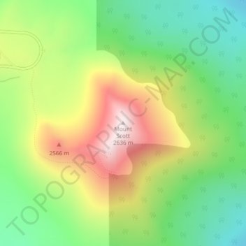
Naam: Topografische kaart Mount Scott, hoogte, reliëf.
Locatie: Mount Scott, Klamath County, Oregon, United States (42.92295 -122.01626 42.92305 -122.01616)
Gemiddelde hoogte: 2.295 m
Minimale hoogte: 2.004 m
Maximale hoogte: 2.703 m
There is one trail to the summit of Mount Scott. Starting on Rim Drive, the trail is about 2.5 miles (4.0 km) long. It has many switchbacks, and ends at the fire lookout tower on the summit. The trailhead is at an elevation of 7,683 feet (2,342 m), and the trail climbs approximately 1,479 feet (451 m) to the top of Mount Scott at 8,934 feet (2,723 m).
Andere topografische kaarten
Klik op een kaart om zijn topografie, zijn hoogte en zijn reliëf te bekijken.
Klamath Falls
United States > Oregon > Klamath County
Klamath Falls, Klamath County, Oregon, 97601, United States
Gemiddelde hoogte: 1.312 m
Dairy
United States > Oregon > Klamath County
Dairy, Klamath County, Oregon, 97625, United States
Gemiddelde hoogte: 1.300 m
Crater Lake National Park
United States > Oregon > Klamath County
Crater Lake National Park, Klamath County, Oregon, 97604, United States
Gemiddelde hoogte: 1.726 m
Rock Point
United States > Oregon > Klamath County
Rock Point, Klamath County, Oregon, 97731, United States
Gemiddelde hoogte: 1.415 m
Altamont
United States > Oregon > Klamath County
Altamont, Klamath County, Oregon, 97603, United States
Gemiddelde hoogte: 1.310 m
Lake of the Woods
United States > Oregon > Klamath County
Lake of the Woods, Klamath County, Oregon, United States
Gemiddelde hoogte: 1.588 m
Chemult
United States > Oregon > Klamath County
Chemult, Klamath County, Oregon, United States
Gemiddelde hoogte: 1.480 m
Crescent
United States > Oregon > Klamath County
Crescent, Klamath County, Oregon, United States
Gemiddelde hoogte: 1.389 m
Sprague River
United States > Oregon > Klamath County
Sprague River, Klamath County, Oregon, 97639, United States
Gemiddelde hoogte: 1.472 m
Malin
United States > Oregon > Klamath County
Malin, Klamath County, Oregon, United States
Gemiddelde hoogte: 1.241 m
Altamont
United States > Oregon > Klamath County > Altamont
Altamont, Klamath County, Oregon, 97603, United States
Gemiddelde hoogte: 1.285 m
Merrill
United States > Oregon > Klamath County
Merrill, Klamath County, Oregon, United States
Gemiddelde hoogte: 1.241 m
Fort Klamath
United States > Oregon > Klamath County
Fort Klamath, Klamath County, Oregon, United States
Gemiddelde hoogte: 1.273 m
Chiloquin
United States > Oregon > Klamath County
Chiloquin, Klamath County, Oregon, United States
Gemiddelde hoogte: 1.302 m
Beatty
United States > Oregon > Klamath County
Beatty, Klamath County, Oregon, 97602, United States
Gemiddelde hoogte: 1.330 m
Odell Lake
United States > Oregon > Klamath County > Odell Lake
Odell Lake, Klamath County, Oregon, United States
Gemiddelde hoogte: 1.492 m
Crater Lake
United States > Oregon > Klamath County
Crater Lake, Klamath County, Oregon, United States
Gemiddelde hoogte: 1.971 m
Bonanza
United States > Oregon > Klamath County
Bonanza, Klamath County, Oregon, United States
Gemiddelde hoogte: 1.263 m
Keno
United States > Oregon > Klamath County
Keno, Klamath County, Oregon, 97627, United States
Gemiddelde hoogte: 1.287 m
Mount Mazama
United States > Oregon > Klamath County
Mount Mazama, Klamath County, Oregon, United States
Gemiddelde hoogte: 1.880 m