
Topografische kaart Xã Trị An
Interactieve kaart
Klik op de kaart om de hoogte weer te geven.
Over deze kaart
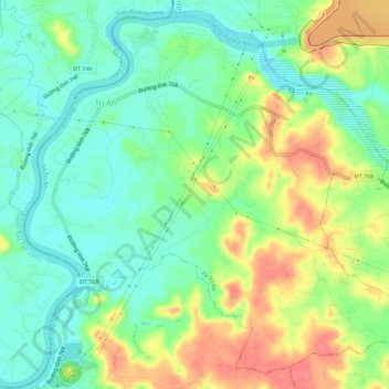
Naam: Topografische kaart Xã Trị An, hoogte, reliëf.
Locatie: Xã Trị An, Vĩnh Cửu District, Đồng Nai Province, Vietnam (11.05885 106.94487 11.10819 106.99965)
Gemiddelde hoogte: 28 m
Minimale hoogte: -1 m
Maximale hoogte: 70 m
Andere topografische kaarten
Klik op een kaart om zijn topografie, zijn hoogte en zijn reliëf te bekijken.
Xã Thiện Tân
Vietnam > Dong Nai province > Vĩnh Cửu District
Xã Thiện Tân, Vĩnh Cửu District, Đồng Nai Province, 76913, Vietnam
Gemiddelde hoogte: 20 m
Xã Tân An
Vietnam > Dong Nai province > Vĩnh Cửu District
Xã Tân An, Vĩnh Cửu District, Đồng Nai Province, Vietnam
Gemiddelde hoogte: 23 m
Xã Mã Đà
Vietnam > Dong Nai province > Vĩnh Cửu District
Xã Mã Đà, Vĩnh Cửu District, Đồng Nai Province, Vietnam
Gemiddelde hoogte: 65 m
Xã Bình Lợi
Vietnam > Dong Nai province > Vĩnh Cửu District
Xã Bình Lợi, Vĩnh Cửu District, Đồng Nai Province, Vietnam
Gemiddelde hoogte: 9 m