
Doe een donatie
Rust jezelf uit voor je volgende avontuur:
Als Amazon-partner verdient deze site een commissie op in aanmerking komende aankopen, zonder extra kosten voor jou.
Topografische kaart Albano Laziale
Klik op de kaart om de hoogte weer te geven.
Doe een donatie
Rust jezelf uit voor je volgende avontuur:
Als Amazon-partner verdient deze site een commissie op in aanmerking komende aankopen, zonder extra kosten voor jou.
Albano Laziale
The highest peak of the town of Albano is the Colle dei Cappuccini, located at 615 m above sea level. From the hill, which houses a pine forest adjacent to the Capuchin Monastery, there is a remarkable overview of Lake Albano, Agro Romano and Monte Cavo. The historic center of Albano has a maximum gradient of 11%, or 47 metres, 435, taking into consideration the distance between the Cathedral of San Pancrazio (384 m asl) and the St. Paul's Church (431 m asl). Other altitudes through the center of town are Villa Altieri, at kilometre 25 of the State Road 7 Via Appia (363 m asl) and the Church of Stella (391 m asl). The hill town of Castel Savelli is 280 m above sea level, while the underlying fraction of Pavona is built at 110 m above sea level. The village of Cecchina at the railway station is located at 212 m above sea level.
Doe een donatie
Rust jezelf uit voor je volgende avontuur:
Als Amazon-partner verdient deze site een commissie op in aanmerking komende aankopen, zonder extra kosten voor jou.
Over deze kaart
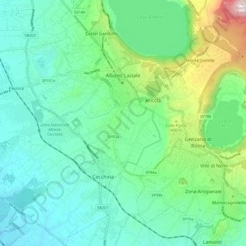
Naam: Topografische kaart Albano Laziale, hoogte, reliëf.
Locatie: Albano Laziale, Roma Capitale, Lazio, 00041, Italy (41.67321 12.59029 41.75334 12.69444)
Gemiddelde hoogte: 302 m
Minimale hoogte: 106 m
Maximale hoogte: 951 m
Doe een donatie
Rust jezelf uit voor je volgende avontuur:
Als Amazon-partner verdient deze site een commissie op in aanmerking komende aankopen, zonder extra kosten voor jou.
Andere topografische kaarten
Klik op een kaart om zijn topografie, zijn hoogte en zijn reliëf te bekijken.
Rome
Italy > Lazio > Roma Capitale
Although the city centre is about 24 km (15 mi) inland from the Tyrrhenian Sea, the city territory extends to the shore, where the south-western district of Ostia is located. The altitude of the central part of Rome ranges from 13 m (43 ft) above sea level (at the base of the Pantheon) to 139 m (456 ft) above…
Gemiddelde hoogte: 78 m
Doe een donatie
Rust jezelf uit voor je volgende avontuur:
Als Amazon-partner verdient deze site een commissie op in aanmerking komende aankopen, zonder extra kosten voor jou.
Doe een donatie
Rust jezelf uit voor je volgende avontuur:
Als Amazon-partner verdient deze site een commissie op in aanmerking komende aankopen, zonder extra kosten voor jou.
Doe een donatie
Rust jezelf uit voor je volgende avontuur:
Als Amazon-partner verdient deze site een commissie op in aanmerking komende aankopen, zonder extra kosten voor jou.
Doe een donatie
Rust jezelf uit voor je volgende avontuur:
Als Amazon-partner verdient deze site een commissie op in aanmerking komende aankopen, zonder extra kosten voor jou.