
Topografische kaart Brussels–Scheldt Maritime Canal
Interactieve kaart
Klik op de kaart om de hoogte weer te geven.
Over deze kaart
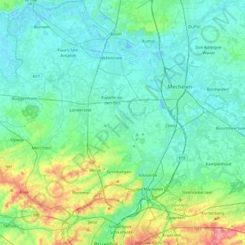
Naam: Topografische kaart Brussels–Scheldt Maritime Canal, hoogte, reliëf.
Gemiddelde hoogte: 22 m
Minimale hoogte: -3 m
Maximale hoogte: 110 m
The difference in altitude of 14 m between Brussels and the Rupel river at Willebroek was achieved with 4 locks. With the commissioning of the canal, the ships could now avoid navigating the Zenne and being subject to tax in Mechelen.
Andere topografische kaarten
Klik op een kaart om zijn topografie, zijn hoogte en zijn reliëf te bekijken.
Woluwe
Belgium > Flemish Brabant > Brussels-Capital > Brussels
Woluwe, Brussels, City of Brussels, Brussels-Capital, Flemish Brabant, Brussels-Capital, 1831, Belgium
Gemiddelde hoogte: 64 m