
Topografische kaart Modale
Interactieve kaart
Klik op de kaart om de hoogte weer te geven.
Over deze kaart
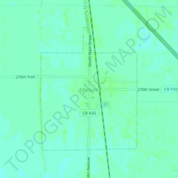
Naam: Topografische kaart Modale, hoogte, reliëf.
Locatie: Modale, Harrison County, Iowa, United States (41.61052 -96.02188 41.62917 -96.00229)
Gemiddelde hoogte: 307 m
Minimale hoogte: 303 m
Maximale hoogte: 310 m
Andere topografische kaarten
Klik op een kaart om zijn topografie, zijn hoogte en zijn reliëf te bekijken.
Logan
United States > Iowa > Harrison County
Logan, Harrison County, Iowa, 51546, United States
Gemiddelde hoogte: 337 m
Magnolia
United States > Iowa > Harrison County
Magnolia, Harrison County, Iowa, 51550, United States
Gemiddelde hoogte: 381 m
Persia
United States > Iowa > Harrison County
Persia, Harrison County, Iowa, United States
Gemiddelde hoogte: 367 m
Mondamin
United States > Iowa > Harrison County
Mondamin, Harrison County, Iowa, United States
Gemiddelde hoogte: 310 m
Yorkshire
United States > Iowa > Harrison County
Yorkshire, Harrison County, Iowa, United States
Gemiddelde hoogte: 368 m
Missouri Valley
United States > Iowa > Harrison County
Missouri Valley, Harrison County, Iowa, 51555, United States
Gemiddelde hoogte: 321 m
Dunlap
United States > Iowa > Harrison County
Dunlap, Harrison County, Iowa, 51529, United States
Gemiddelde hoogte: 347 m
Woodbine
United States > Iowa > Harrison County
Woodbine, Harrison County, Iowa, United States
Gemiddelde hoogte: 328 m
Little Sioux
United States > Iowa > Harrison County
Little Sioux, Harrison County, Iowa, United States
Gemiddelde hoogte: 315 m
Pisgah
United States > Iowa > Harrison County
Pisgah, Harrison County, Iowa, United States
Gemiddelde hoogte: 342 m