
Topografische kaart John Day
Interactieve kaart
Klik op de kaart om de hoogte weer te geven.
Over deze kaart
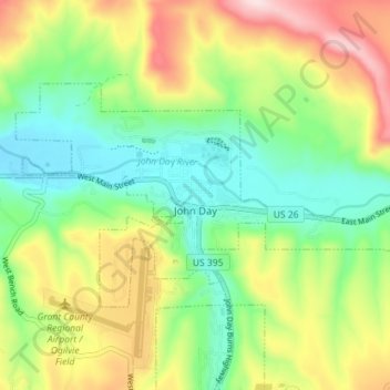
Naam: Topografische kaart John Day, hoogte, reliëf.
Locatie: John Day, Grant County, Oregon, 97845, United States (44.40318 -118.98629 44.43233 -118.91518)
Gemiddelde hoogte: 1.047 m
Minimale hoogte: 918 m
Maximale hoogte: 1.254 m
John Day is at an elevation of 3,087 feet (941 m). According to the United States Census Bureau, the city has a total area of 1.87 square miles (4.84 km2), all land.
Andere topografische kaarten
Klik op een kaart om zijn topografie, zijn hoogte en zijn reliëf te bekijken.
Granite
United States > Oregon > Grant County
Granite, Grant County, Oregon, United States
Gemiddelde hoogte: 1.475 m
Robinsonville
United States > Oregon > Grant County
Robinsonville, Grant County, Oregon, United States
Gemiddelde hoogte: 1.858 m
Austin
United States > Oregon > Grant County
Austin, Grant County, Oregon, United States
Gemiddelde hoogte: 1.312 m
Monument
United States > Oregon > Grant County
Monument, Grant County, Oregon, United States
Gemiddelde hoogte: 640 m
Kimberly
United States > Oregon > Grant County
Kimberly, Grant County, Oregon, United States
Gemiddelde hoogte: 711 m
Desolation Butte
United States > Oregon > Grant County
Desolation Butte, Grant County, Oregon, United States
Gemiddelde hoogte: 1.949 m
Rabbit Ears
United States > Oregon > Grant County
Rabbit Ears, Grant County, Oregon, United States
Gemiddelde hoogte: 2.285 m
Canyon City
United States > Oregon > Grant County
Canyon City, Grant County, Oregon, 97820, United States
Gemiddelde hoogte: 1.078 m
Prairie City
United States > Oregon > Grant County > Prairie City
Prairie City, Grant County, Oregon, United States
Gemiddelde hoogte: 1.104 m