
Doe een donatie
Rust jezelf uit voor je volgende avontuur:
Als Amazon-partner verdient deze site een commissie op in aanmerking komende aankopen, zonder extra kosten voor jou.
Topografische kaart Muntanyola
Klik op de kaart om de hoogte weer te geven.
Doe een donatie
Rust jezelf uit voor je volgende avontuur:
Als Amazon-partner verdient deze site een commissie op in aanmerking komende aankopen, zonder extra kosten voor jou.
Muntanyola
The village of Muntanyola is a-typical in that it does not have a center. 75% of the municipality's area consists of forested hills between 650 and 1000 m. altitude, with scattered farms and fields. The build-up area is in the higher elevations and mainly consists of two real estate developments - in Spanish: 'urbanizations' - called Muntanyola and Fontanelles, respectively. Both these neighbourhoods consist of lanes with upmarket free-standing villa's with large gardens. Centrally located in the 'Muntanyola urbanization' are the school, a tennis court, sports hall, swimming pool, playground and restaurant. The church and town hall stand rather isolated in the hills on the northern side of the Muntanyola-development. The municipality also includes the old hamlet of Múnter in its lower elevations, sloping down to the Plain of Vic (Plana de Vic). The municipality is also odd in that its territory consists of four non-contiguous areas, i.e. a main area with three exclaves. Muntanyola, Fontanelles and Múnter are all in the main area, but Múnter can be reached from Muntanyola by a rural path or via the territory of the adjacent municipality of Tona
Doe een donatie
Rust jezelf uit voor je volgende avontuur:
Als Amazon-partner verdient deze site een commissie op in aanmerking komende aankopen, zonder extra kosten voor jou.
Over deze kaart
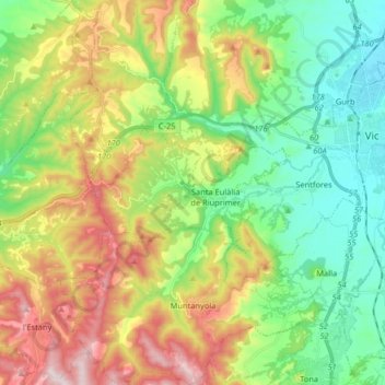
Naam: Topografische kaart Muntanyola, hoogte, reliëf.
Locatie: Muntanyola, Osona, Barcelona, Catalonia, 08529, Spain (41.85207 2.09069 41.97270 2.23168)
Gemiddelde hoogte: 678 m
Minimale hoogte: 470 m
Maximale hoogte: 1.029 m
Doe een donatie
Rust jezelf uit voor je volgende avontuur:
Als Amazon-partner verdient deze site een commissie op in aanmerking komende aankopen, zonder extra kosten voor jou.
Andere topografische kaarten
Klik op een kaart om zijn topografie, zijn hoogte en zijn reliëf te bekijken.