
Topografische kaart Pembina Valley Provincial Park
Interactieve kaart
Klik op de kaart om de hoogte weer te geven.
Over deze kaart
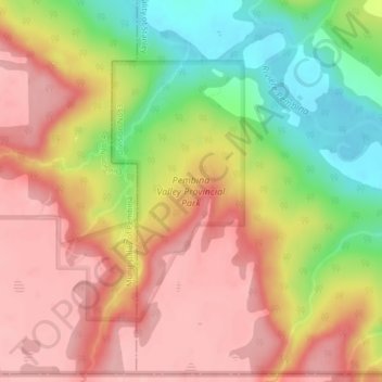
Naam: Topografische kaart Pembina Valley Provincial Park, hoogte, reliëf.
Gemiddelde hoogte: 414 m
Minimale hoogte: 333 m
Maximale hoogte: 470 m
Andere topografische kaarten
Klik op een kaart om zijn topografie, zijn hoogte en zijn reliëf te bekijken.
Hochfeld
Canada > Manitoba > Division No. 3 > Rural Municipality of Stanley > Hochfeld
Hochfeld, Rural Municipality of Stanley, Division No. 3, Manitoba, Canada
Gemiddelde hoogte: 284 m
Chortitz
Canada > Manitoba > Division No. 3 > Rural Municipality of Stanley
Chortitz, Rural Municipality of Stanley, Division No. 3, Manitoba, R6W 1M2, Canada
Gemiddelde hoogte: 285 m