
Topografische kaart Raisin River
Interactieve kaart
Klik op de kaart om de hoogte weer te geven.
Over deze kaart
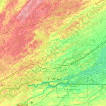
Naam: Topografische kaart Raisin River, hoogte, reliëf.
Gemiddelde hoogte: 73 m
Minimale hoogte: 43 m
Maximale hoogte: 124 m
Andere topografische kaarten
Klik op een kaart om zijn topografie, zijn hoogte en zijn reliëf te bekijken.
Apple Hill
Canada > Ontario > Stormont, Dundas and Glengarry Counties > North Glengarry
Apple Hill, North Glengarry, Stormont, Dundas and Glengarry Counties, Eastern Ontario, Ontario, K0C 1B0, Canada
Gemiddelde hoogte: 90 m
Iroquois
Canada > Ontario > Stormont, Dundas and Glengarry Counties > South Dundas
Iroquois, South Dundas, Stormont, Dundas and Glengarry Counties, Eastern Ontario, Ontario, K0E 1K0, Canada
Gemiddelde hoogte: 83 m
Morrisburg
Canada > Ontario > Stormont, Dundas and Glengarry Counties > South Dundas
Morrisburg, South Dundas, Stormont, Dundas and Glengarry Counties, Eastern Ontario, Ontario, K0C 1X0, Canada
Gemiddelde hoogte: 79 m
Alexandria
Canada > Ontario > Stormont, Dundas and Glengarry Counties > North Glengarry
Alexandria, North Glengarry, Stormont, Dundas and Glengarry Counties, Eastern Ontario, Ontario, K0C 1A0, Canada
Gemiddelde hoogte: 84 m
Lunenburg
Canada > Ontario > Stormont, Dundas and Glengarry Counties > South Stormont
Lunenburg, South Stormont, Stormont, Dundas and Glengarry Counties, Eastern Ontario, Ontario, K0C 1R0, Canada
Gemiddelde hoogte: 83 m
South Stormont
Canada > Ontario > Stormont, Dundas and Glengarry Counties > South Stormont
South Stormont, Stormont, Dundas and Glengarry Counties, Eastern Ontario, Ontario, Canada
Gemiddelde hoogte: 81 m
Macdonald Island
Canada > Ontario > Stormont, Dundas and Glengarry Counties > South Dundas
Macdonald Island, South Dundas, Stormont, Dundas and Glengarry Counties, Eastern Ontario, Ontario, Canada
Gemiddelde hoogte: 75 m
Baltics Corners
Canada > Ontario > Stormont, Dundas and Glengarry Counties > North Glengarry
Baltics Corners, North Glengarry, Stormont, Dundas and Glengarry Counties, Eastern Ontario, Ontario, Canada
Gemiddelde hoogte: 95 m