
Topografische kaart Orford
Interactieve kaart
Klik op de kaart om de hoogte weer te geven.
Over deze kaart
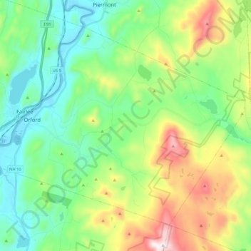
Naam: Topografische kaart Orford, hoogte, reliëf.
Locatie: Orford, Grafton County, New Hampshire, United States (43.83795 -72.17370 43.95761 -71.96389)
Gemiddelde hoogte: 300 m
Minimale hoogte: 111 m
Maximale hoogte: 979 m
Andere topografische kaarten
Klik op een kaart om zijn topografie, zijn hoogte en zijn reliëf te bekijken.
Canaan
United States > New Hampshire > Grafton County
Canaan, Grafton County, New Hampshire, 03741, United States
Gemiddelde hoogte: 404 m
Lyman
United States > New Hampshire > Grafton County
Lyman, Grafton County, New Hampshire, United States
Gemiddelde hoogte: 347 m
Warren
United States > New Hampshire > Grafton County
Warren, Grafton County, New Hampshire, United States
Gemiddelde hoogte: 475 m
Bonsai
United States > New Hampshire > Grafton County > Rumney
Bonsai, Rumney, Grafton County, New Hampshire, 03266, United States
Gemiddelde hoogte: 246 m
Franconia
United States > New Hampshire > Grafton County
Franconia, Grafton County, New Hampshire, 03580, United States
Gemiddelde hoogte: 558 m
Waterville Valley
United States > New Hampshire > Grafton County
Waterville Valley, Grafton County, New Hampshire, 03215, United States
Gemiddelde hoogte: 649 m
Groton
United States > New Hampshire > Grafton County
Groton, Grafton County, New Hampshire, United States
Gemiddelde hoogte: 366 m
Plymouth
United States > New Hampshire > Grafton County
Plymouth, Grafton County, New Hampshire, 03264, United States
Gemiddelde hoogte: 264 m
Wentworth
United States > New Hampshire > Grafton County
Wentworth, Grafton County, New Hampshire, 03282, United States
Gemiddelde hoogte: 422 m
Bath
United States > New Hampshire > Grafton County
Bath, Grafton County, New Hampshire, 03740, United States
Gemiddelde hoogte: 289 m
Stinson Lake
United States > New Hampshire > Grafton County > Rumney > Stinson Lake
Stinson Lake, Rumney, Grafton County, New Hampshire, United States
Gemiddelde hoogte: 460 m
North Haverhill
United States > New Hampshire > Grafton County > Haverhill
North Haverhill, Haverhill, Grafton County, New Hampshire, 03774, United States
Gemiddelde hoogte: 149 m
Echo Lake
United States > New Hampshire > Grafton County > Franconia
Echo Lake, Franconia, Grafton County, New Hampshire, United States
Gemiddelde hoogte: 693 m
Lebanon
United States > New Hampshire > Grafton County
Lebanon, Grafton County, New Hampshire, United States
Gemiddelde hoogte: 274 m
Mount Kineo, East Peak
United States > New Hampshire > Grafton County > Ellsworth
Mount Kineo, East Peak, Ellsworth, Grafton County, New Hampshire, United States
Gemiddelde hoogte: 710 m
Holderness
United States > New Hampshire > Grafton County
Holderness, Grafton County, New Hampshire, 03245, United States
Gemiddelde hoogte: 252 m
Etna
United States > New Hampshire > Grafton County > Hanover
Etna, Hanover, Grafton County, New Hampshire, 03750, United States
Gemiddelde hoogte: 296 m
Bristol
United States > New Hampshire > Grafton County
Bristol, Grafton County, New Hampshire, 03222, United States
Gemiddelde hoogte: 254 m
Enfield
United States > New Hampshire > Grafton County
Enfield, Grafton County, New Hampshire, United States
Gemiddelde hoogte: 366 m
Sugar Hill
United States > New Hampshire > Grafton County > Sugar Hill
Sugar Hill, Grafton County, New Hampshire, 03586, United States
Gemiddelde hoogte: 372 m
Mount Agassiz
United States > New Hampshire > Grafton County > Bethlehem
Mount Agassiz, Bethlehem, Grafton County, New Hampshire, 03574, United States
Gemiddelde hoogte: 558 m
Littleton
United States > New Hampshire > Grafton County > Littleton
Littleton, Grafton County, New Hampshire, United States
Gemiddelde hoogte: 360 m
North Littleton
United States > New Hampshire > Grafton County > Littleton > North Littleton
North Littleton, Littleton, Grafton County, New Hampshire, United States
Gemiddelde hoogte: 333 m
West Lebanon
United States > New Hampshire > Grafton County > Lebanon > West Lebanon
West Lebanon, Lebanon, Grafton County, New Hampshire, 03784, United States
Gemiddelde hoogte: 165 m
Lebanon
United States > New Hampshire > Grafton County > Lebanon
Lebanon, Grafton County, New Hampshire, 03766-1355, United States
Gemiddelde hoogte: 315 m
LeBruns Mobile Home Park
United States > New Hampshire > Grafton County > Lebanon > LeBruns Mobile Home Park
LeBruns Mobile Home Park, Lebanon, Grafton County, New Hampshire, United States
Gemiddelde hoogte: 326 m
Thornton
United States > New Hampshire > Grafton County
Thornton, Grafton County, New Hampshire, United States
Gemiddelde hoogte: 474 m
Bethlehem
United States > New Hampshire > Grafton County > Bethlehem
Bethlehem, Grafton County, New Hampshire, 03574, United States
Gemiddelde hoogte: 528 m
Easton
United States > New Hampshire > Grafton County
Easton, Grafton County, New Hampshire, United States
Gemiddelde hoogte: 586 m
Lincoln
United States > New Hampshire > Grafton County
Lincoln, Grafton County, New Hampshire, 03251, United States
Gemiddelde hoogte: 677 m
Lyme
United States > New Hampshire > Grafton County
Lyme, Grafton County, New Hampshire, United States
Gemiddelde hoogte: 297 m