
Topografische kaart Prato (Leventina)
Interactieve kaart
Klik op de kaart om de hoogte weer te geven.
Over deze kaart
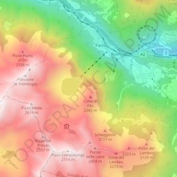
Naam: Topografische kaart Prato (Leventina), hoogte, reliëf.
Gemiddelde hoogte: 1.755 m
Minimale hoogte: 801 m
Maximale hoogte: 2.688 m
The municipality is located in the Leventina district, in a depression in the mountains at an elevation of 1,046 m (3,432 ft) near the Monte Piottino gorge. It consists of the village of Prato and the hamlets of Fiesso, Mascengo, Rodi and Morasco.
Andere topografische kaarten
Klik op een kaart om zijn topografie, zijn hoogte en zijn reliëf te bekijken.
Sobrio
Switzerland > Ticino > Distretto di Leventina > Sobrio
Sobrio, Faido, Circolo di Giornico, Distretto di Leventina, Ticino, 6749, Switzerland
Gemiddelde hoogte: 1.112 m
Ambrì
Switzerland > Ticino > Distretto di Leventina
Ambrì, Quinto, Circolo di Quinto, Distretto di Leventina, Ticino, 6775, Switzerland
Gemiddelde hoogte: 1.459 m