
Topografische kaart Newcastle
Interactieve kaart
Klik op de kaart om de hoogte weer te geven.
Over deze kaart
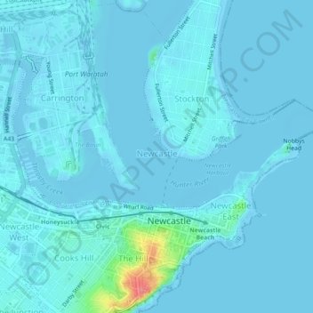
Naam: Topografische kaart Newcastle, hoogte, reliëf.
Gemiddelde hoogte: 5 m
Minimale hoogte: -3 m
Maximale hoogte: 76 m
Andere topografische kaarten
Klik op een kaart om zijn topografie, zijn hoogte en zijn reliëf te bekijken.
Merewether
Australia > New South Wales > Newcastle
Merewether, Newcastle, Newcastle-Maitland, Newcastle City Council, New South Wales, 2291, Australia
Gemiddelde hoogte: 23 m
Bar Beach
Australia > New South Wales > Newcastle
Bar Beach, Newcastle, Newcastle-Maitland, Newcastle City Council, New South Wales, 2300, Australia
Gemiddelde hoogte: 10 m
Whitebridge
Australia > New South Wales > Newcastle
Whitebridge, Newcastle, Newcastle-Maitland, Lake Macquarie City Council, New South Wales, 2290, Australia
Gemiddelde hoogte: 64 m
Killingworth
Australia > New South Wales > Newcastle
Killingworth, Newcastle, Newcastle-Maitland, Lake Macquarie City Council, New South Wales, 2278, Australia
Gemiddelde hoogte: 60 m
Newcastle
Australia > New South Wales > Newcastle
Newcastle, Newcastle-Maitland, Newcastle City Council, New South Wales, 2300, Australia
Gemiddelde hoogte: 9 m