
Topografische kaart Upper Lough Erne
Interactieve kaart
Klik op de kaart om de hoogte weer te geven.
Over deze kaart
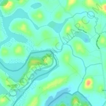
Naam: Topografische kaart Upper Lough Erne, hoogte, reliëf.
Gemiddelde hoogte: 50 m
Minimale hoogte: 40 m
Maximale hoogte: 78 m
Andere topografische kaarten
Klik op een kaart om zijn topografie, zijn hoogte en zijn reliëf te bekijken.
Drumquin
United Kingdom > Northern Ireland > County Tyrone
Drumquin, County Tyrone, Northern Ireland, BT78 4SB, United Kingdom
Gemiddelde hoogte: 97 m
Mourne Mountains Middle
United Kingdom > Northern Ireland > County Down
Mourne Mountains Middle, County Down, Northern Ireland, United Kingdom
Gemiddelde hoogte: 348 m
Kildrum
United Kingdom > Northern Ireland
Kildrum, Fermanagh and Omagh District, Northern Ireland, United Kingdom
Gemiddelde hoogte: 100 m
Portadown
United Kingdom > Northern Ireland > County Armagh
Portadown, County Armagh, Northern Ireland, BT62 1BF, United Kingdom
Gemiddelde hoogte: 28 m
Antrim
United Kingdom > Northern Ireland > County Antrim
Antrim, County Antrim, Northern Ireland, BT41 4AR, United Kingdom
Gemiddelde hoogte: 50 m
Drains Bay
United Kingdom > Northern Ireland > County Antrim
Drains Bay, County Antrim, Northern Ireland, BT40 2LG, United Kingdom
Gemiddelde hoogte: 38 m
Carnlough
United Kingdom > Northern Ireland > County Antrim
Carnlough, County Antrim, Northern Ireland, BT44 0EU, United Kingdom
Gemiddelde hoogte: 77 m
Droghed
United Kingdom > Northern Ireland
Droghed, Northern Ireland, United Kingdom
Gemiddelde hoogte: 16 m
Downpatrick
United Kingdom > Northern Ireland
Downpatrick, Newry, Mourne and Down District Council, Northern Ireland, BT30 6BB, United Kingdom
Gemiddelde hoogte: 25 m
Portrush
United Kingdom > Northern Ireland > County Antrim
Portrush, County Antrim, Northern Ireland, BT56 8BN, United Kingdom
Gemiddelde hoogte: 23 m
Banbridge
United Kingdom > Northern Ireland > County Down
Banbridge, County Down, Northern Ireland, BT32 3DB, United Kingdom
Gemiddelde hoogte: 90 m
Kilclief
United Kingdom > Northern Ireland
Kilclief, Newry, Mourne and Down District Council, Northern Ireland, BT30 7AR, United Kingdom
Gemiddelde hoogte: 6 m
Newtownabbey
United Kingdom > Northern Ireland > County Antrim
Newtownabbey, County Antrim, Northern Ireland, BT36 6UN, United Kingdom
Gemiddelde hoogte: 100 m
Newry
United Kingdom > Northern Ireland > Newry
Newry, Newry, Mourne and Down District Council, Northern Ireland, United Kingdom
Gemiddelde hoogte: 119 m
Carryduff
United Kingdom > Northern Ireland > Carryduff
Carryduff, County Down, Northern Ireland, BT8 8DN, United Kingdom
Gemiddelde hoogte: 121 m
Creeve
United Kingdom > Northern Ireland
Creeve, Northern Ireland, United Kingdom
Gemiddelde hoogte: 71 m
Fermanagh and Omagh District
United Kingdom > Northern Ireland
Fermanagh and Omagh District, Northern Ireland, United Kingdom
Gemiddelde hoogte: 141 m
County Armagh
United Kingdom > Northern Ireland
County Armagh, Northern Ireland, United Kingdom
Gemiddelde hoogte: 98 m
Clonmore
United Kingdom > Northern Ireland
Clonmore, Northern Ireland, United Kingdom
Gemiddelde hoogte: 19 m
Knappagh
United Kingdom > Northern Ireland
Knappagh, Northern Ireland, United Kingdom
Gemiddelde hoogte: 83 m
Loughmacrory
United Kingdom > Northern Ireland > County Tyrone > Loughmacrory
Loughmacrory, County Tyrone, Ulster, Northern Ireland, BT79 9LG, United Kingdom
Gemiddelde hoogte: 190 m
Ulster
United Kingdom > Northern Ireland
Ulster, Northern Ireland, United Kingdom
Gemiddelde hoogte: 71 m
Carricknagapple
United Kingdom > Northern Ireland > County Tyrone
Carricknagapple, County Tyrone, Ulster, Northern Ireland, BT79 9AF, United Kingdom
Gemiddelde hoogte: 212 m
Oughterard
United Kingdom > Northern Ireland
Oughterard, Ulster, Northern Ireland, United Kingdom
Gemiddelde hoogte: 115 m
Carricknameeltage
United Kingdom > Northern Ireland > County Tyrone
Carricknameeltage, County Tyrone, Ulster, Northern Ireland, BT79 9AF, United Kingdom
Gemiddelde hoogte: 212 m
Skerries
United Kingdom > Northern Ireland
Skerries, Northern Ireland, United Kingdom
Gemiddelde hoogte: 83 m
Armagh
United Kingdom > Northern Ireland > County Armagh > Milford
Armagh, Milford, County Armagh, Ulster, Northern Ireland, United Kingdom
Gemiddelde hoogte: 100 m
Layd
United Kingdom > Northern Ireland
Layd, Ulster, Northern Ireland, United Kingdom
Gemiddelde hoogte: 77 m
Dunseverick Castle
United Kingdom > Northern Ireland > County Antrim > Dunseverick
Dunseverick Castle, Causeway Coastal Way, Dunseverick, County Antrim, Ulster, Northern Ireland, BT57 8SR, United Kingdom
Gemiddelde hoogte: 29 m
Belfast
United Kingdom > Northern Ireland > County Antrim
Belfast, County Antrim, Ulster, Northern Ireland, BT1 5GS, United Kingdom
Gemiddelde hoogte: 87 m
Seafin
United Kingdom > Northern Ireland > County Armagh
Seafin, County Armagh, Ulster, Northern Ireland, United Kingdom
Gemiddelde hoogte: 161 m
County Tyrone
United Kingdom > Northern Ireland
County Tyrone, Northern Ireland, United Kingdom
Gemiddelde hoogte: 128 m
Newry
United Kingdom > Northern Ireland > County Down
Newry, County Down, Northern Ireland, United Kingdom
Gemiddelde hoogte: 73 m
Mullaghcarn
United Kingdom > Northern Ireland > County Tyrone
Mullaghcarn, County Tyrone, Ulster, Northern Ireland, BT79 8PU, United Kingdom
Gemiddelde hoogte: 386 m
Rathkenny
United Kingdom > Northern Ireland > County Antrim
Rathkenny, County Antrim, Ulster, Northern Ireland, United Kingdom
Gemiddelde hoogte: 147 m
Newtownhamilton
United Kingdom > Northern Ireland > County Armagh
Newtownhamilton, County Armagh, Ulster, Northern Ireland, BT35 0PB, United Kingdom
Gemiddelde hoogte: 222 m
Maghery
United Kingdom > Northern Ireland > County Armagh
Maghery, County Armagh, Ulster, Northern Ireland, BT71 6PA, United Kingdom
Gemiddelde hoogte: 14 m
Cornagee
United Kingdom > Northern Ireland
Cornagee, Ulster, Northern Ireland, United Kingdom
Gemiddelde hoogte: 91 m
Dromore
United Kingdom > Northern Ireland > County Down
Dromore, County Down, Ulster, Northern Ireland, BT25 1BD, United Kingdom
Gemiddelde hoogte: 106 m
Rooskey
United Kingdom > Northern Ireland > County Tyrone
Rooskey, County Tyrone, Ulster, Northern Ireland, BT78 3EE, United Kingdom
Gemiddelde hoogte: 133 m
Lismaine
United Kingdom > Northern Ireland
Lismaine, Ulster, Northern Ireland, United Kingdom
Gemiddelde hoogte: 51 m
River Foyle
United Kingdom > Northern Ireland > Londonderry/Derry
River Foyle, Londonderry/Derry, County Londonderry, Northern Ireland, BT47 1DH, United Kingdom
Gemiddelde hoogte: 61 m
Hamiltons Bawn
United Kingdom > Northern Ireland > County Armagh
Hamiltons Bawn, County Armagh, Ulster, Northern Ireland, BT61 9SA, United Kingdom
Gemiddelde hoogte: 101 m
Drumaness
United Kingdom > Northern Ireland > County Down > Drumaness
Drumaness, County Down, Northern Ireland, BT24 8RL, United Kingdom
Gemiddelde hoogte: 74 m
Martinstown
United Kingdom > Northern Ireland > County Antrim > Martinstown
Martinstown, County Antrim, Northern Ireland, BT43 6QH, United Kingdom
Gemiddelde hoogte: 174 m
Drumenny (Stewart)
United Kingdom > Northern Ireland
Drumenny (Stewart), Northern Ireland, United Kingdom
Gemiddelde hoogte: 31 m
Drumshanbo
United Kingdom > Northern Ireland > County Tyrone
Drumshanbo, County Tyrone, Northern Ireland, BT78 4PT, United Kingdom
Gemiddelde hoogte: 84 m
Derry/Londonderry
United Kingdom > Northern Ireland > County Londonderry
Derry/Londonderry, County Borough of Londonderry, County Londonderry, Northern Ireland, BT48 6BU, United Kingdom
Gemiddelde hoogte: 88 m
Cloghram
United Kingdom > Northern Ireland
Cloghram, Northern Ireland, BT30 8RE, United Kingdom
Gemiddelde hoogte: 24 m
Claggan
United Kingdom > Northern Ireland > County Tyrone
Claggan, County Tyrone, Ulster, Northern Ireland, United Kingdom
Gemiddelde hoogte: 84 m