
Topografische kaart Telluride
Interactieve kaart
Klik op de kaart om de hoogte weer te geven.
Over deze kaart
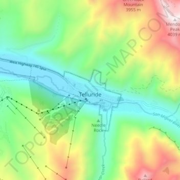
Naam: Topografische kaart Telluride, hoogte, reliëf.
Gemiddelde hoogte: 3.125 m
Minimale hoogte: 2.647 m
Maximale hoogte: 4.023 m
Telluride has an elevation of 8,750 feet (2,670 m) in an isolated spot in Southwest Colorado. From the west, Colorado Route 145 is the most common way into Telluride; two other passes enter the town, Imogene Pass and Black Bear Pass.