
Topografische kaart Malvern
Klik op de kaart om de hoogte weer te geven.
Malvern
Malvern lies in the Lower Severn/Avon plain affording it a degree of shelter caused by virtue of its nestling in between the Cotswold hills to the east, the Welsh Hills and Mountains to the west, and Birmingham plateau to the north. Although as with all the British Isles it has a maritime climate, the local topography means summer warmth can become emphasised by a slight foehn effect off the surrounding hills. The record maximum stands at 35.8c(96.4f) set in August 1990. Typically 17.3 days of the year will reach 25.1c(77.2f) or higher and the annual warmest day should reach 29.8c(85.6f) according to the 1971–00 observing period.
Over deze kaart
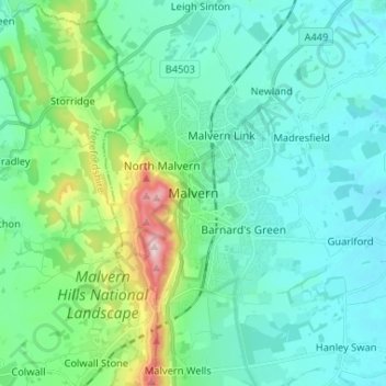
Naam: Topografische kaart Malvern, hoogte, reliëf.
Gemiddelde hoogte: 95 m
Minimale hoogte: 19 m
Maximale hoogte: 423 m
Andere topografische kaarten
Klik op een kaart om zijn topografie, zijn hoogte en zijn reliëf te bekijken.
West Malvern
United Kingdom > England > Worcestershire > Malvern Hills
West Malvern is a village and a civil parish on the west side of the north part of the Malvern Hills, on the western edge of Worcestershire, England. It has become effectively a suburb of Malvern and part of an urban area often called The Malverns, locally administered by Malvern Hills District Council and its…
Gemiddelde hoogte: 198 m
Broadheath
United Kingdom > England > Worcestershire > Malvern Hills > Lower Broadheath
Gemiddelde hoogte: 44 m
Knighton on Teme
United Kingdom > England > Worcestershire > Malvern Hills > Knighton on Teme
Gemiddelde hoogte: 82 m