
Topografische kaart Hameau des Bordes
Interactieve kaart
Klik op de kaart om de hoogte weer te geven.
Over deze kaart
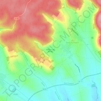
Naam: Topografische kaart Hameau des Bordes, hoogte, reliëf.
Gemiddelde hoogte: 212 m
Minimale hoogte: 147 m
Maximale hoogte: 297 m
Andere topografische kaarten
Klik op een kaart om zijn topografie, zijn hoogte en zijn reliëf te bekijken.
La Montée
France > Grand Est > Aube > Eaux-Puiseaux
La Montée, Eaux-Puiseaux, Troyes, Aube, Grand Est, France métropolitaine, 10130, France
Gemiddelde hoogte: 249 m
Hameau d'Eaux
France > Grand Est > Aube > Eaux-Puiseaux
Hameau d'Eaux, Eaux-Puiseaux, Troyes, Aube, Grand Est, France métropolitaine, 10130, France
Gemiddelde hoogte: 231 m