
Topografische kaart Clifton
Interactieve kaart
Klik op de kaart om de hoogte weer te geven.
Over deze kaart
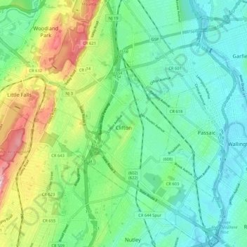
Naam: Topografische kaart Clifton, hoogte, reliëf.
Locatie: Clifton, Passaic County, New Jersey, United States (40.81993 -74.19773 40.89940 -74.11780)
Gemiddelde hoogte: 56 m
Minimale hoogte: 1 m
Maximale hoogte: 187 m
Andere topografische kaarten
Klik op een kaart om zijn topografie, zijn hoogte en zijn reliëf te bekijken.
West Milford
United States > New Jersey > Passaic County
West Milford, Passaic County, New Jersey, United States
Gemiddelde hoogte: 262 m
Bloomingdale
United States > New Jersey > Passaic County
Bloomingdale, Passaic County, New Jersey, 07403, United States
Gemiddelde hoogte: 157 m
Wanaque
United States > New Jersey > Passaic County
Wanaque, Passaic County, New Jersey, United States
Gemiddelde hoogte: 125 m
Upper Macopin
United States > New Jersey > Passaic County > West Milford
Upper Macopin, West Milford, Passaic County, New Jersey, 07480, United States
Gemiddelde hoogte: 298 m
Hewitt
United States > New Jersey > Passaic County > West Milford
Hewitt, West Milford, Passaic County, New Jersey, 10979, United States
Gemiddelde hoogte: 185 m
Wayne
United States > New Jersey > Passaic County
Wayne, Passaic County, New Jersey, 07470, United States
Gemiddelde hoogte: 86 m
Paterson
United States > New Jersey > Passaic County
Paterson, Passaic County, New Jersey, United States
Gemiddelde hoogte: 54 m
Dundee Dam
United States > New Jersey > Passaic County > Clifton
Dundee Dam, Clifton, Passaic County, New Jersey, 07011, United States
Gemiddelde hoogte: 18 m
Haledon
United States > New Jersey > Passaic County
Haledon, Passaic County, New Jersey, United States
Gemiddelde hoogte: 81 m
Pompton Lakes
United States > New Jersey > Passaic County
Pompton Lakes, Passaic County, New Jersey, 07442, United States
Gemiddelde hoogte: 87 m
Hawthorne
United States > New Jersey > Passaic County
Hawthorne, Passaic County, New Jersey, 07506, United States
Gemiddelde hoogte: 62 m
Paterson Great Falls National Historical Park
United States > New Jersey > Passaic County > Paterson
Paterson Great Falls National Historical Park, Paterson, Passaic County, New Jersey, United States
Gemiddelde hoogte: 45 m
Upper Greenwood Lake
United States > New Jersey > Passaic County > West Milford
Upper Greenwood Lake, West Milford, Passaic County, New Jersey, 07421, United States
Gemiddelde hoogte: 360 m
Paterson
United States > New Jersey > Passaic County > Paterson
Paterson, Passaic County, New Jersey, 07505, United States
Gemiddelde hoogte: 74 m
North Haledon
United States > New Jersey > Passaic County
North Haledon, Passaic County, New Jersey, 07508, United States
Gemiddelde hoogte: 132 m
Passaic
United States > New Jersey > Passaic County > Passaic
Passaic, Passaic County, New Jersey, 07055, United States
Gemiddelde hoogte: 31 m
Athenia
United States > New Jersey > Passaic County > Clifton > Athenia
Athenia, Clifton, Passaic County, New Jersey, 07015, United States
Gemiddelde hoogte: 44 m
Richfield
United States > New Jersey > Passaic County > Clifton > Richfield
Richfield, Clifton, Passaic County, New Jersey, 07013, United States
Gemiddelde hoogte: 72 m
Ringwood
United States > New Jersey > Passaic County > Ringwood
Ringwood, Passaic County, New Jersey, 07456, United States
Gemiddelde hoogte: 176 m
Woodland Park
United States > New Jersey > Passaic County
Woodland Park, Passaic County, New Jersey, 07424, United States
Gemiddelde hoogte: 86 m
Totowa
United States > New Jersey > Passaic County
Totowa, Passaic County, New Jersey, 07512, United States
Gemiddelde hoogte: 69 m