
Topografische kaart Harford County
Interactieve kaart
Klik op de kaart om de hoogte weer te geven.
Over deze kaart
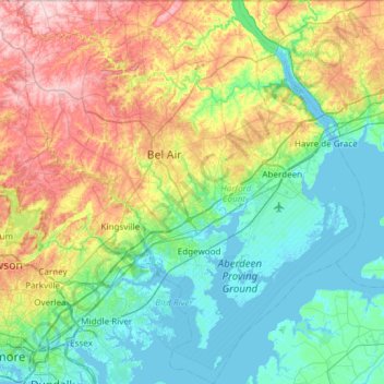
Naam: Topografische kaart Harford County, hoogte, reliëf.
Locatie: Harford County, Maryland, United States of America (39.25801 -76.56923 39.72121 -76.03564)
Gemiddelde hoogte: 70 m
Minimale hoogte: -3 m
Maximale hoogte: 237 m
Harford County straddles the border between the rolling hills of the Piedmont Plateau and the flatlands of the Atlantic Coastal Plain along the Chesapeake Bay and its tributaries. The county's development is a mix of rural and suburban, with denser development in the larger towns of Aberdeen and Bel Air and along Route 40 and other major arteries leading out of Baltimore. The highest elevations are in the north and northwest of the county, reaching 805 ft. near the Pennsylvania border in the county's northwestern corner. The lowest elevation is sea level along the Chesapeake Bay.
Andere topografische kaarten
Klik op een kaart om zijn topografie, zijn hoogte en zijn reliëf te bekijken.
Wicomico County
United States of America > Maryland
Wicomico County, Maryland, United States of America
Gemiddelde hoogte: 9 m
Prince George's County
United States of America > Maryland
Prince George's County, Maryland, United States of America
Gemiddelde hoogte: 45 m
Bethesda
United States of America > Maryland > Bethesda
Bethesda, Montgomery County, Maryland, United States of America
Gemiddelde hoogte: 81 m
Bethesda
United States of America > Maryland > Bethesda
Bethesda, Montgomery County, Maryland, 22814, United States of America
Gemiddelde hoogte: 86 m