
Topografische kaart Evans County
Interactieve kaart
Klik op de kaart om de hoogte weer te geven.
Over deze kaart
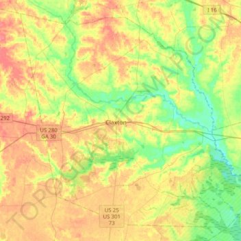
Naam: Topografische kaart Evans County, hoogte, reliëf.
Locatie: Evans County, Georgia, United States of America (32.04790 -82.02575 32.27889 -81.71866)
Gemiddelde hoogte: 47 m
Minimale hoogte: 19 m
Maximale hoogte: 78 m
Air travel in Evans County is provided by the Claxton-Evans County Airport. The site for the airport was approved by the FAA in 1964 and it was activated in 1971; the airport is three miles (5 km) northeast of Claxton, Georgia. It is operated by the city of Claxton. It has a 5,000-foot (1,500 m) runway, hangars, pilot control lighting, and a Precision Approach Path Indicator. The Claxton-Evans County Airport has an elevation of 112 ft (34.1 m).
Andere topografische kaarten
Klik op een kaart om zijn topografie, zijn hoogte en zijn reliëf te bekijken.
Murray County
United States of America > Georgia
Murray County, Georgia, United States of America
Gemiddelde hoogte: 381 m
Coffee County
United States of America > Georgia
Coffee County, Georgia, United States of America
Gemiddelde hoogte: 72 m
Bibb County
United States of America > Georgia
Bibb County, Georgia, United States of America
Gemiddelde hoogte: 128 m