
Topografische kaart Riley County
Interactieve kaart
Klik op de kaart om de hoogte weer te geven.
Over deze kaart
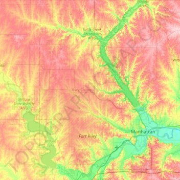
Naam: Topografische kaart Riley County, hoogte, reliëf.
Locatie: Riley County, Kansas, United States of America (39.04332 -96.96157 39.56651 -96.38904)
Gemiddelde hoogte: 382 m
Minimale hoogte: 298 m
Maximale hoogte: 467 m
Andere topografische kaarten
Klik op een kaart om zijn topografie, zijn hoogte en zijn reliëf te bekijken.
McPherson County
United States of America > Kansas
McPherson County, Kansas, United States of America
Gemiddelde hoogte: 455 m
Gardner
United States of America > Kansas > Gardner
Gardner, Johnson County, Kansas, 66030, United States of America
Gemiddelde hoogte: 317 m
Great Bend
United States of America > Kansas > Great Bend
Great Bend, Barton County, Kansas, United States of America
Gemiddelde hoogte: 570 m
Gove County
United States of America > Kansas
Gove County, Kansas, United States of America
Gemiddelde hoogte: 825 m
Suicide Bluffs
United States of America > Kansas
Suicide Bluffs, West Scott Lake Drive, Scott County, Kansas, United States of America
Gemiddelde hoogte: 891 m
Wheaton
United States of America > Kansas > Wheaton
Wheaton, Pottawatomie County, Kansas, United States of America
Gemiddelde hoogte: 454 m
Radium
United States of America > Kansas > Radium
Radium, Stafford County, Kansas, United States of America
Gemiddelde hoogte: 596 m
Whitewater
United States of America > Kansas > Whitewater
Whitewater, Butler County, Kansas, United States of America
Gemiddelde hoogte: 419 m
Sawyer
United States of America > Kansas > Sawyer
Sawyer, Pratt County, Kansas, United States of America
Gemiddelde hoogte: 582 m
Attica
United States of America > Kansas > Attica
Attica, Harper County, Kansas, United States of America
Gemiddelde hoogte: 445 m
Hodgeman County
United States of America > Kansas
Hodgeman County, Kansas, United States of America
Gemiddelde hoogte: 729 m
Comanche County
United States of America > Kansas
Comanche County, Kansas, United States of America
Gemiddelde hoogte: 595 m
Clark County
United States of America > Kansas
Clark County, Kansas, United States of America
Gemiddelde hoogte: 660 m
Wallace County
United States of America > Kansas
Wallace County, Kansas, United States of America
Gemiddelde hoogte: 1.102 m
Junction City
United States of America > Kansas > Junction City
Junction City, Geary County, Kansas, United States of America
Gemiddelde hoogte: 352 m
Woodson County
United States of America > Kansas
Woodson County, Kansas, United States of America
Gemiddelde hoogte: 317 m
Alma
United States of America > Kansas > Alma
Alma, Wabaunsee County, Kansas, United States of America
Gemiddelde hoogte: 334 m
Craig
United States of America > Kansas > Lenexa > Craig
Craig, Lenexa, Johnson County, Kansas, 64500, United States of America
Gemiddelde hoogte: 288 m
Copeland
United States of America > Kansas > Copeland
Copeland, Gray County, Kansas, United States of America
Gemiddelde hoogte: 862 m
Keeler
United States of America > Kansas > Keeler
Keeler, Sedgwick County, Kansas, 67221, United States of America
Gemiddelde hoogte: 398 m
Dickinson County
United States of America > Kansas
Dickinson County, Kansas, United States of America
Gemiddelde hoogte: 387 m