
Topografische kaart Greenwood County
Interactieve kaart
Klik op de kaart om de hoogte weer te geven.
Over deze kaart
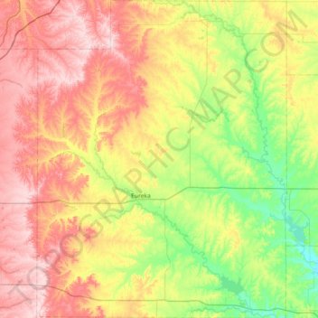
Naam: Topografische kaart Greenwood County, hoogte, reliëf.
Locatie: Greenwood County, Kansas, United States of America (37.60338 -96.52556 38.17407 -95.95884)
Gemiddelde hoogte: 372 m
Minimale hoogte: 266 m
Maximale hoogte: 507 m
Andere topografische kaarten
Klik op een kaart om zijn topografie, zijn hoogte en zijn reliëf te bekijken.
Lawrence
United States of America > Kansas > Lawrence
Lawrence, Douglas County, Kansas, United States of America
Gemiddelde hoogte: 265 m
Seward County
United States of America > Kansas
Seward County, Kansas, United States of America
Gemiddelde hoogte: 866 m