Geolokaliseren
👉 Easily get elevation data in JSON, GeoTIFF and KML formats using Elevation API
Bedankt voor het steunen van deze site ❤️
Doe een donatie

Rust jezelf uit voor je volgende avontuur:

Als Amazon-partner verdient deze site een commissie op in aanmerking komende aankopen, zonder extra kosten voor jou.

Topografische kaart Madurai

Klik op de kaart om de hoogte weer te geven.

👉 Easily get elevation data in JSON, GeoTIFF and KML formats using Elevation API
Bedankt voor het steunen van deze site ❤️
Doe een donatie

Rust jezelf uit voor je volgende avontuur:

Als Amazon-partner verdient deze site een commissie op in aanmerking komende aankopen, zonder extra kosten voor jou.

Madurai

Madurai is located at 9°56′N 78°07′E / 9.93°N 78.12°E / 9.93; 78.12. It has an average elevation of 101 metres. The city of Madurai lies on the flat and fertile plain of the river Vaigai, which runs in the northwest-southeast direction through the city, dividing it into two almost equal halves. The Sirumalai and Nagamalai hills lie to the north and west of Madurai. The land in and around Madurai is utilised largely for agricultural activity, which is fostered by the Periyar Dam. Madurai lies southeast of the western ghats, and the surrounding region occupies the plains of South India and contains several mountain spurs. The soil type in central Madurai is predominantly clay loam, while red loam and black cotton types are widely prevalent in the outer fringes of the city. Paddy is the major crop, followed by pulses, millet, oil seed, cotton and sugarcane.

👉 Easily get elevation data in JSON, GeoTIFF and KML formats using Elevation API
Bedankt voor het steunen van deze site ❤️
Doe een donatie

Rust jezelf uit voor je volgende avontuur:

Als Amazon-partner verdient deze site een commissie op in aanmerking komende aankopen, zonder extra kosten voor jou.

Over deze kaart

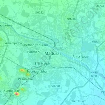
Naam: Topografische kaart Madurai, hoogte, reliëf.

Locatie: Madurai, Madurai South, Madurai district, Tamil Nadu, India (9.87138 78.03678 9.98257 78.16689)

Gemiddelde hoogte: 138 m

Minimale hoogte: 118 m

Maximale hoogte: 319 m

👉 Easily get elevation data in JSON, GeoTIFF and KML formats using Elevation API
Bedankt voor het steunen van deze site ❤️
Doe een donatie

Rust jezelf uit voor je volgende avontuur:

Als Amazon-partner verdient deze site een commissie op in aanmerking komende aankopen, zonder extra kosten voor jou.

Rust jezelf uit voor je volgende avontuur:

🧤Outdoor Accessoires - Onmisbare aanvullingen voor elke hike
📱Outdoor Smartphonehouders - Bescherm je smartphone tijdens hikes
Fietspompen - Houd je bandenspanning optimaal voor elk terrein
Outdoor GPS Horloges - Multifunctionele GPS-horloges voor wandelen en trail
🔥Camping Kooktoestellen - Warm eten onderweg tijdens hikes

Als Amazon-partner verdient deze site een commissie op in aanmerking komende aankopen, zonder extra kosten voor jou.