
Topografische kaart Mauzé-Thouarsais
Interactieve kaart
Klik op de kaart om de hoogte weer te geven.
Over deze kaart
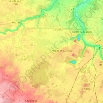
Naam: Topografische kaart Mauzé-Thouarsais, hoogte, reliëf.
Gemiddelde hoogte: 97 m
Minimale hoogte: 21 m
Maximale hoogte: 165 m
Andere topografische kaarten
Klik op een kaart om zijn topografie, zijn hoogte en zijn reliëf te bekijken.
Féolles
France > Nouvelle-Aquitaine > Deux-Sèvres > Thouars
Féolles, Thouars, Bressuire, Deux-Sèvres, Nouvelle-Aquitaine, France métropolitaine, 79100, France
Gemiddelde hoogte: 88 m
Thouars
France > Nouvelle-Aquitaine > Deux-Sèvres > Thouars
Thouars, Bressuire, Deux-Sèvres, Nouvelle-Aquitaine, France métropolitaine, 79100, France
Gemiddelde hoogte: 84 m