
Doe een donatie
Rust jezelf uit voor je volgende avontuur:
Als Amazon-partner verdient deze site een commissie op in aanmerking komende aankopen, zonder extra kosten voor jou.
Topografische kaart Dyatlov Pass
Klik op de kaart om de hoogte weer te geven.
Doe een donatie
Rust jezelf uit voor je volgende avontuur:
Als Amazon-partner verdient deze site een commissie op in aanmerking komende aankopen, zonder extra kosten voor jou.
Dyatlov Pass
Diaries and cameras found around their last campsite made it possible to track the group's route up to the day preceding the incident. On 31 January, the group arrived at the edge of a highland area and began to prepare for climbing. In a wooded valley, they cached surplus food and equipment that would be used for the trip back. The next day, the hikers started to move through the pass. It seems they planned to get over the pass and make camp for the next night on the opposite side, but because of worsening weather conditions—snowstorms and decreasing visibility—they lost their direction and deviated west, toward the top of Kholat Syakhl. When they realised their mistake, the group decided to set up camp there on the slope of the mountain, rather than move 1.5 kilometres (0.93 mi) downhill to a forested area that would have offered some shelter from the weather. Yudin speculated, "Dyatlov probably did not want to lose the altitude they had gained, or he decided to practice camping on the mountain slope."
Doe een donatie
Rust jezelf uit voor je volgende avontuur:
Als Amazon-partner verdient deze site een commissie op in aanmerking komende aankopen, zonder extra kosten voor jou.
Over deze kaart
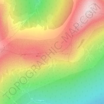
Naam: Topografische kaart Dyatlov Pass, hoogte, reliëf.
Gemiddelde hoogte: 707 m
Minimale hoogte: 494 m
Maximale hoogte: 899 m
Doe een donatie
Rust jezelf uit voor je volgende avontuur:
Als Amazon-partner verdient deze site een commissie op in aanmerking komende aankopen, zonder extra kosten voor jou.