
Doe een donatie
Rust jezelf uit voor je volgende avontuur:
Als Amazon-partner verdient deze site een commissie op in aanmerking komende aankopen, zonder extra kosten voor jou.
Topografische kaart MacLean Settlement Brook
Klik op de kaart om de hoogte weer te geven.
Doe een donatie
Rust jezelf uit voor je volgende avontuur:
Als Amazon-partner verdient deze site een commissie op in aanmerking komende aankopen, zonder extra kosten voor jou.
Over deze kaart
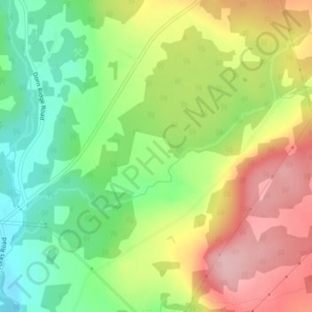
Naam: Topografische kaart MacLean Settlement Brook, hoogte, reliëf.
Gemiddelde hoogte: 103 m
Minimale hoogte: 20 m
Maximale hoogte: 200 m
Doe een donatie
Rust jezelf uit voor je volgende avontuur:
Als Amazon-partner verdient deze site een commissie op in aanmerking komende aankopen, zonder extra kosten voor jou.
Andere topografische kaarten
Klik op een kaart om zijn topografie, zijn hoogte en zijn reliëf te bekijken.
Manners Sutton Parish
Canada > New Brunswick > York County > Harvey Rural Community
Gemiddelde hoogte: 138 m
Kingsclear Parish
Canada > New Brunswick > York County > Hanwell Rural Community
Gemiddelde hoogte: 109 m
Doe een donatie
Rust jezelf uit voor je volgende avontuur:
Als Amazon-partner verdient deze site een commissie op in aanmerking komende aankopen, zonder extra kosten voor jou.
Doe een donatie
Rust jezelf uit voor je volgende avontuur:
Als Amazon-partner verdient deze site een commissie op in aanmerking komende aankopen, zonder extra kosten voor jou.
City of Fredericton
Canada > New Brunswick > York County
At an altitude of about 17 m (56 ft) above sea level, Fredericton is nestled in the Pennsylvanian Basin. It differs markedly from the geologically older parts of the province. There are prominently two distinct areas in the region that are divided around the area of Wilsey Road, in the east end of the city. In…
Gemiddelde hoogte: 73 m
Fredericton
Canada > New Brunswick > York County
At an altitude of about 17 m (56 ft) above sea level, Fredericton is nestled in the Pennsylvanian Basin. It differs markedly from the geologically older parts of the province. There are prominently two distinct areas in the region that are divided around the area of Wilsey Road, in the east end of the city. In…
Gemiddelde hoogte: 73 m
Doe een donatie
Rust jezelf uit voor je volgende avontuur:
Als Amazon-partner verdient deze site een commissie op in aanmerking komende aankopen, zonder extra kosten voor jou.