
Topografische kaart Ball Ground
Interactieve kaart
Klik op de kaart om de hoogte weer te geven.
Ball Ground
According to the United States Census Bureau, the city has a total area of 5.8 square miles (15.1 km2), of which 0.031 square miles (0.08 km2), or 0.50%, is water. The city's elevation averages around 1,100 feet (340 m) above sea level, ranging from just over 1,000 feet (300 m) in the valleys to around 1,200 feet (370 m) on several hilltops within the city.
Over deze kaart
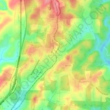
Naam: Topografische kaart Ball Ground, hoogte, reliëf.
Locatie: Ball Ground, Cherokee County, Georgia, 30107, United States (34.31823 -84.39657 34.35823 -84.35657)
Gemiddelde hoogte: 332 m
Minimale hoogte: 281 m
Maximale hoogte: 383 m