
Topografische kaart Durham
Interactieve kaart
Klik op de kaart om de hoogte weer te geven.
Over deze kaart
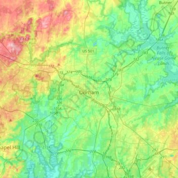
Naam: Topografische kaart Durham, hoogte, reliëf.
Locatie: Durham, Durham County, North Carolina, United States (35.86635 -79.00750 36.13701 -78.75959)
Gemiddelde hoogte: 117 m
Minimale hoogte: 61 m
Maximale hoogte: 238 m
Durham is located in the east-central part of the Piedmont region at 35°59′19″N 78°54′26″W / 35.98861°N 78.90722°W / 35.98861; -78.90722 (35.988644, −78.907167). Like much of the region, its topography is generally flat with some rolling hills.
Andere topografische kaarten
Klik op een kaart om zijn topografie, zijn hoogte en zijn reliëf te bekijken.
Few
United States > North Carolina > Durham County > Durham
Few, Durham, Durham County, North Carolina, 27713, United States
Gemiddelde hoogte: 102 m
Brassfield
United States > North Carolina > Durham County > Durham
Brassfield, Durham, Durham County, North Carolina, 27703, United States
Gemiddelde hoogte: 113 m
Durham
United States > North Carolina > Durham County > Durham
Durham, Durham County, North Carolina, 27701, United States
Gemiddelde hoogte: 119 m
Eno River
United States > North Carolina > Durham County
Eno River, Durham County, North Carolina, 27705, United States
Gemiddelde hoogte: 134 m
Belmont Lake
United States > North Carolina > Durham County > Durham
Belmont Lake, Crest Street, Durham, Durham County, North Carolina, United States
Gemiddelde hoogte: 117 m
Hayes
United States > North Carolina > Durham County > Durham
Hayes, Durham, Durham County, North Carolina, 27702, United States
Gemiddelde hoogte: 115 m