
Topografische kaart Meron
Interactieve kaart
Klik op de kaart om de hoogte weer te geven.
Over deze kaart
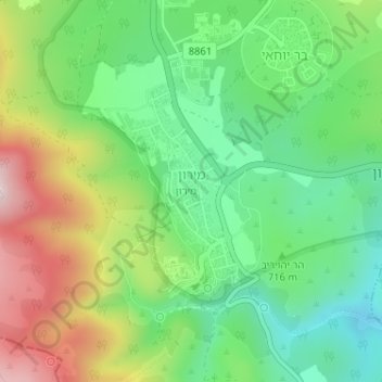
Naam: Topografische kaart Meron, hoogte, reliëf.
Gemiddelde hoogte: 735 m
Minimale hoogte: 571 m
Maximale hoogte: 1.004 m
Meron is noted for its mountainous terrain and valleys. Among the local attractions are the Meron Vineyards. Meron is conducive to growing grapes for wine as a result of its 600-meter altitude and chalky soil. The vineyard was first planted in 2000 and is part of the Galil Mountain Winery, headquartered in nearby Kibbutz Yiron.
Andere topografische kaarten
Klik op een kaart om zijn topografie, zijn hoogte en zijn reliëf te bekijken.
Livnim
Israel > North District > Merom HaGalil Regional Council
Livnim, Merom HaGalil Regional Council, Safed Subdistrict, North District, Israel
Gemiddelde hoogte: -83 m
Amirim
Israel > North District > Merom HaGalil Regional Council
Amirim, Merom HaGalil Regional Council, Safed Subdistrict, North District, Israel
Gemiddelde hoogte: 512 m
Avivim
Israel > North District > Merom HaGalil Regional Council > Avivim
Avivim, Merom HaGalil Regional Council, Safed Subdistrict, North District, Israel
Gemiddelde hoogte: 704 m
Mount Meron
Israel > North District > Merom HaGalil Regional Council
Mount Meron, Merom HaGalil Regional Council, Safed Subdistrict, North District, Israel
Gemiddelde hoogte: 943 m