
Topografische kaart Launceston
Interactieve kaart
Klik op de kaart om de hoogte weer te geven.
Over deze kaart
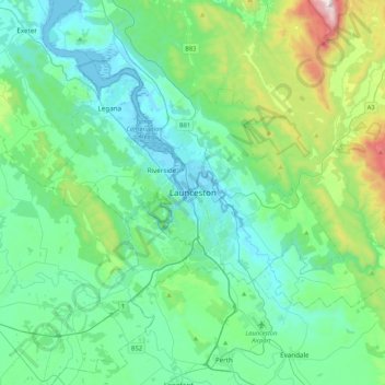
Naam: Topografische kaart Launceston, hoogte, reliëf.
Locatie: Launceston, Tasmania, 7250, Australia (-41.59408 146.97735 -41.27408 147.29735)
Gemiddelde hoogte: 218 m
Minimale hoogte: -3 m
Maximale hoogte: 1.171 m
Launceston is at 41°26′31″S 147°8′42″E / 41.44194°S 147.14500°E / -41.44194; 147.14500 in the Tamar Valley, Northern Tasmania. The valley was formed by volcanic and glacial forces over 10 million years ago. The city is about 45 kilometres (28 mi) south of the Bass Strait, with its closest neighbour-city being Devonport, about 99 kilometres (62 mi) to the north west. Launceston combines steep (originally heavily wooded) ridges and low-lying areas (originally wetlands – with parts of the suburbs of Inveresk and Invermay below high-tide level). As a result, areas of Launceston are subject to landslip problems, while others are liable to poor drainage and periodic flooding. The topography of the area is not conducive to easy dispersion of airborne pollution, due to the phenomenon of thermal inversion.
Andere topografische kaarten
Klik op een kaart om zijn topografie, zijn hoogte en zijn reliëf te bekijken.
Prospect Vale
Australia > Tasmania > Launceston
Prospect Vale, Launceston, Meander Valley, Tasmania, 7250, Australia
Gemiddelde hoogte: 174 m
South Esk River
Australia > Tasmania > Launceston
South Esk River, Launceston, Tasmania, 7250, Australia
Gemiddelde hoogte: 153 m