
Topografische kaart Braamfontein Spruit
Interactieve kaart
Klik op de kaart om de hoogte weer te geven.
Over deze kaart
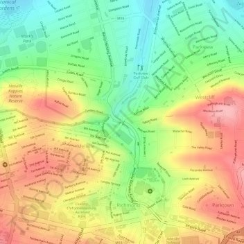
Naam: Topografische kaart Braamfontein Spruit, hoogte, reliëf.
Gemiddelde hoogte: 1.672 m
Minimale hoogte: 1.602 m
Maximale hoogte: 1.736 m
Andere topografische kaarten
Klik op een kaart om zijn topografie, zijn hoogte en zijn reliëf te bekijken.
Zoo Lake
RSA > Gauteng > Johannesburg
Zoo Lake, Johannesburg Ward 117, Johannesburg, City of Johannesburg Metropolitan Municipality, Gauteng, 2001, RSA
Gemiddelde hoogte: 1.647 m
Johannesburg Ward 60
RSA > Gauteng > Johannesburg
Johannesburg Ward 60, Johannesburg, City of Johannesburg Metropolitan Municipality, Gauteng, 2001, RSA
Gemiddelde hoogte: 1.736 m
Kliprivier
RSA > Gauteng > Johannesburg
Kliprivier, Johannesburg, City of Johannesburg Metropolitan Municipality, Gauteng, 2001, RSA
Gemiddelde hoogte: 1.531 m
Johannesburg Ward 87
RSA > Gauteng > Johannesburg
Johannesburg Ward 87, Johannesburg, City of Johannesburg Metropolitan Municipality, Gauteng, 2001, RSA
Gemiddelde hoogte: 1.661 m
Mary Fitzgerald Square
RSA > Gauteng > Johannesburg
Mary Fitzgerald Square, Johannesburg Ward 60, Johannesburg, City of Johannesburg Metropolitan Municipality, Gauteng, 2001, RSA
Gemiddelde hoogte: 1.738 m