
Topografische kaart Tagum
Interactieve kaart
Klik op de kaart om de hoogte weer te geven.
Over deze kaart
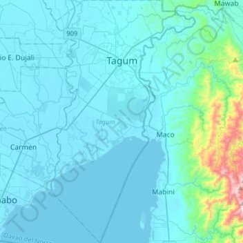
Naam: Topografische kaart Tagum, hoogte, reliëf.
Locatie: Tagum, Davao del Norte, Davao Region, 8100, Philippines (7.25404 125.73317 7.51058 125.88730)
Gemiddelde hoogte: 91 m
Minimale hoogte: 0 m
Maximale hoogte: 1.117 m
One of the significant accomplishments of the officialdom of Tagum during the 1990s was its elevation from a second to the first-class municipality. This opened a gateway to increase its financial resources through the Internal Revenue Allocation (IRA) from the national government and local revenues. This was under the leadership of Hon Victorio R. Suaybaguio, Jr. who sat as mayor Tagum for three consecutive terms (1988–1998). As a matter of fact, during the 1995 election, all incumbent elected officials of Tagum, from Mayor down to the municipal councilors, were unopposed, making a significant event in the political history of Tagum.
Andere topografische kaarten
Klik op een kaart om zijn topografie, zijn hoogte en zijn reliëf te bekijken.
Balet
Philippines > Davao del Norte > Samal
Balet, Babak District, Samal, Davao del Norte, Davao Region, Philippines
Gemiddelde hoogte: 63 m
Adecor
Philippines > Davao del Norte > Samal
Adecor, Kaputian District, Samal, Davao del Norte, Davao Region, Philippines
Gemiddelde hoogte: 88 m
Samal
Samal, Davao del Norte, Davao Region, Philippines
Gemiddelde hoogte: 37 m
Panabo
Philippines > Davao del Norte > Panabo
Panabo, Davao del Norte, Davao Region, 8105, Philippines
Gemiddelde hoogte: 20 m
San Remegio
Philippines > Davao del Norte > Samal > San Remegio
San Remegio, Kaputian District, Samal, Davao del Norte, Davao Region, Philippines
Gemiddelde hoogte: 53 m
San Nicolas
Philippines > Davao del Norte > San Nicolas
San Nicolas, Davao del Norte, Davao Region, Philippines
Gemiddelde hoogte: 36 m
Tagum
Philippines > Davao del Norte > Tagum
Tagum, Davao del Norte, Davao Region, 8100, Philippines
Gemiddelde hoogte: 103 m