
Topografische kaart Cape Chignecto Provincial Park
Interactieve kaart
Klik op de kaart om de hoogte weer te geven.
Over deze kaart
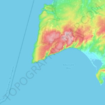
Naam: Topografische kaart Cape Chignecto Provincial Park, hoogte, reliëf.
Gemiddelde hoogte: 39 m
Minimale hoogte: -2 m
Maximale hoogte: 280 m
Andere topografische kaarten
Klik op een kaart om zijn topografie, zijn hoogte en zijn reliëf te bekijken.
Cape Chignecto
Canada > Nova Scotia > Cape Chignecto Provincial Park > Cape Chignecto Provincial Park
Cape Chignecto, Cape Chignecto Provincial Park, Municipality of the County of Cumberland, Cumberland County, Nova Scotia, Canada
Gemiddelde hoogte: 20 m