
Topografische kaart Stone Mountain State Park
Interactieve kaart
Klik op de kaart om de hoogte weer te geven.
Over deze kaart
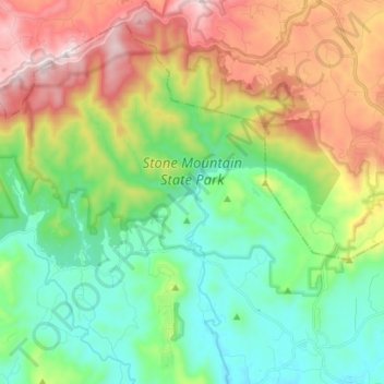
Naam: Topografische kaart Stone Mountain State Park, hoogte, reliëf.
Gemiddelde hoogte: 641 m
Minimale hoogte: 351 m
Maximale hoogte: 1.170 m
The centerpiece of the park is Stone Mountain, a dome of exposed granite (specifically a quartz diorite to granodiorite) of Devonian age, which has intruded into the gneiss of the Precambrian Alligator Back Formation. It rises sharply over 600 feet (183 m) above the surrounding terrain. The mountain, which has an elevation of 2,305 feet (706 m) above sea level, is known for its barren sides and distinctive brown-gray color, and can be seen for miles. The mountain offers some of the best rock climbing in North Carolina, and the park's creeks and streams feature excellent brook trout fishing.
Andere topografische kaarten
Klik op een kaart om zijn topografie, zijn hoogte en zijn reliëf te bekijken.
Wilkesboro
United States > North Carolina > Wilkes County
Wilkesboro, Wilkes County, North Carolina, United States
Gemiddelde hoogte: 352 m
Roaring River
United States > North Carolina > Wilkes County
Roaring River, Wilkes County, North Carolina, United States
Gemiddelde hoogte: 362 m
North Wilkesboro
United States > North Carolina > Wilkes County
North Wilkesboro, Wilkes County, North Carolina, United States
Gemiddelde hoogte: 345 m
Burke Mountain
United States > North Carolina > Wilkes County
Burke Mountain, Wilkes County, North Carolina, 28649, United States
Gemiddelde hoogte: 603 m
Moravian Falls
United States > North Carolina > Wilkes County > Moravian Falls
Moravian Falls, Wilkes County, North Carolina, United States
Gemiddelde hoogte: 361 m