
Topografische kaart Anchorage
Interactieve kaart
Klik op de kaart om de hoogte weer te geven.
Over deze kaart
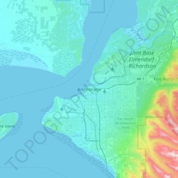
Naam: Topografische kaart Anchorage, hoogte, reliëf.
Locatie: Anchorage, Alaska, 99501, United States (61.05631 -150.05485 61.37631 -149.73485)
Gemiddelde hoogte: 124 m
Minimale hoogte: 0 m
Maximale hoogte: 1.557 m
Andere topografische kaarten
Klik op een kaart om zijn topografie, zijn hoogte en zijn reliëf te bekijken.
Redoubt
United States > Alaska > Anchorage
Redoubt, Anchorage, Alaska, United States
Gemiddelde hoogte: 49 m
Chugiak
United States > Alaska > Anchorage
Chugiak, Anchorage, Alaska, United States
Gemiddelde hoogte: 295 m
Chugach Meadows
United States > Alaska > Anchorage > Anchorage
Chugach Meadows, Anchorage, Alaska, United States
Gemiddelde hoogte: 46 m
Alyeska
United States > Alaska > Anchorage > Girdwood
Alyeska, Girdwood, Anchorage, Alaska, 99523, United States
Gemiddelde hoogte: 256 m
South Yuyanq’ Ch’ex
United States > Alaska > Anchorage
South Yuyanq’ Ch’ex, Anchorage, Alaska, United States
Gemiddelde hoogte: 1.071 m
Knik Arm
United States > Alaska > Anchorage
Knik Arm, Anchorage, Alaska, United States
Gemiddelde hoogte: 72 m
Powder Ridge
United States > Alaska > Anchorage
Powder Ridge, Anchorage, Alaska, United States
Gemiddelde hoogte: 89 m
Girdwood
United States > Alaska > Anchorage
Girdwood, Anchorage, Alaska, 99587, United States
Gemiddelde hoogte: 181 m