
Topografische kaart Lecco
Interactieve kaart
Klik op de kaart om de hoogte weer te geven.
Over deze kaart
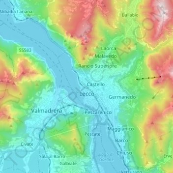
Naam: Topografische kaart Lecco, hoogte, reliëf.
Locatie: Lecco, Lombardy, 23900, Italy (45.81219 9.36677 45.90614 9.48490)
Gemiddelde hoogte: 575 m
Minimale hoogte: 193 m
Maximale hoogte: 1.647 m
The territory has a very variable altimeter distribution: it ranges from 198 metres (650 ft) above sea level in the lake area to the maximum altitude of 1,875 metres (6,152 ft) above the sea level of Mount Resegone and this condition offers the city three different areas characterized by different morphologic and climatic characteristics.
Andere topografische kaarten
Klik op een kaart om zijn topografie, zijn hoogte en zijn reliëf te bekijken.
Monte Resegone
Italy > Lombardy > Lecco > Lecco
Monte Resegone, Lecco, Lombardy, 23900, Italy
Gemiddelde hoogte: 1.371 m
Oliveto Lario
Oliveto Lario, Lecco, Lombardy, 23865, Italy
Gemiddelde hoogte: 569 m