
Topografische kaart Charleston County
Interactieve kaart
Klik op de kaart om de hoogte weer te geven.
Over deze kaart
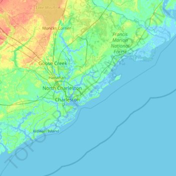
Naam: Topografische kaart Charleston County, hoogte, reliëf.
Locatie: Charleston County, South Carolina, USA (32.49280 -80.45191 33.21502 -79.25611)
Gemiddelde hoogte: 5 m
Minimale hoogte: -4 m
Maximale hoogte: 40 m
Andere topografische kaarten
Klik op een kaart om zijn topografie, zijn hoogte en zijn reliëf te bekijken.
Red Bluff Crossroads
USA > South Carolina > Red Bluff Crossroads
Red Bluff Crossroads, Horry County, South Carolina, USA
Gemiddelde hoogte: 7 m
Simmonsville
USA > South Carolina > Simmonsville
Simmonsville, Georgetown County, South Carolina, USA
Gemiddelde hoogte: 5 m
Grenadier
USA > South Carolina > Grenadier
Grenadier, Lexington County, South Carolina, 29210, USA
Gemiddelde hoogte: 74 m
Cape Romain National Wildlife Refuge
USA > South Carolina > Awendaw
Cape Romain National Wildlife Refuge, Awendaw, Charleston County, South Carolina, USA
Gemiddelde hoogte: 3 m
Tenmile
USA > South Carolina > Tenmile
Tenmile, Charleston County, South Carolina, 29416, USA
Gemiddelde hoogte: 9 m
Walhalla
USA > South Carolina > Walhalla
Walhalla, Oconee County, South Carolina, 29691, USA
Gemiddelde hoogte: 296 m