
Topografische kaart Limberlost Forest and Wildlife Reserve
Interactieve kaart
Klik op de kaart om de hoogte weer te geven.
Over deze kaart
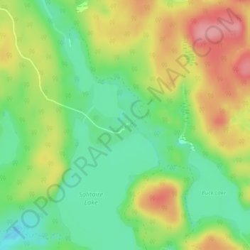
Naam: Topografische kaart Limberlost Forest and Wildlife Reserve, hoogte, reliëf.
Gemiddelde hoogte: 400 m
Minimale hoogte: 352 m
Maximale hoogte: 461 m
Andere topografische kaarten
Klik op een kaart om zijn topografie, zijn hoogte en zijn reliëf te bekijken.
Tackaberry Lake
Canada > Ontario > Muskoka District > Lake of Bays Township
Tackaberry Lake, Lake of Bays Township, District Municipality of Muskoka, Muskoka District, Central Ontario, Ontario, Canada
Gemiddelde hoogte: 338 m
Dwight
Canada > Ontario > Muskoka District > Lake of Bays Township
Dwight, Lake of Bays Township, District Municipality of Muskoka, Muskoka District, Central Ontario, Ontario, Canada
Gemiddelde hoogte: 341 m
Oxbow Lake
Canada > Ontario > Muskoka District > Lake of Bays Township
Oxbow Lake, Lake of Bays Township, District Municipality of Muskoka, Muskoka District, Central Ontario, Ontario, Canada
Gemiddelde hoogte: 400 m