
Topografische kaart Hameau Gosselin
Interactieve kaart
Klik op de kaart om de hoogte weer te geven.
Over deze kaart
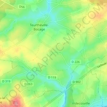
Naam: Topografische kaart Hameau Gosselin, hoogte, reliëf.
Gemiddelde hoogte: 76 m
Minimale hoogte: 41 m
Maximale hoogte: 133 m
Andere topografische kaarten
Klik op een kaart om zijn topografie, zijn hoogte en zijn reliëf te bekijken.
Sainte-Croix
France > Normandie > Manche > Teurthéville-Bocage
Sainte-Croix, Teurthéville-Bocage, Cherbourg, Manche, Normandie, France métropolitaine, 50630, France
Gemiddelde hoogte: 83 m
Le Moulin de Coisel
France > Normandie > Manche > Teurthéville-Bocage
Le Moulin de Coisel, Teurthéville-Bocage, Cherbourg, Manche, Normandie, France métropolitaine, 50630, France
Gemiddelde hoogte: 73 m
Hameau Cadel
France > Normandie > Manche > Teurthéville-Bocage
Hameau Cadel, Teurthéville-Bocage, Cherbourg, Manche, Normandie, France métropolitaine, 50630, France
Gemiddelde hoogte: 74 m