
Topografische kaart Granite Village
Interactieve kaart
Klik op de kaart om de hoogte weer te geven.
Over deze kaart
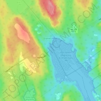
Naam: Topografische kaart Granite Village, hoogte, reliëf.
Gemiddelde hoogte: 35 m
Minimale hoogte: -2 m
Maximale hoogte: 103 m
Andere topografische kaarten
Klik op een kaart om zijn topografie, zijn hoogte en zijn reliëf te bekijken.
Town of Shelburne
Canada > Nova Scotia > Shelburne County
Town of Shelburne, Shelburne County, Nova Scotia, Canada
Gemiddelde hoogte: 28 m
Rockland
Canada > Nova Scotia > Shelburne County
Rockland, Municipality of the District of Shelburne, Shelburne County, Nova Scotia, B0T 1V0, Canada
Gemiddelde hoogte: 12 m
Arnold
Canada > Nova Scotia > Shelburne County > Little Harbour
Arnold, Little Harbour, Municipality of the District of Shelburne, Shelburne County, Nova Scotia, B0T 1V0, Canada
Gemiddelde hoogte: 2 m
Stoney Island
Canada > Nova Scotia > Shelburne County
Stoney Island, Municipality of the District of Barrington, Shelburne County, Nova Scotia, B0W 1P0, Canada
Gemiddelde hoogte: 3 m
Upper Port La Tour
Canada > Nova Scotia > Shelburne County
Upper Port La Tour, Municipality of the District of Barrington, Shelburne County, Nova Scotia, B0W 3N0, Canada
Gemiddelde hoogte: 5 m
Lockeport
Canada > Nova Scotia > Shelburne County
Lockeport, Shelburne County, Nova Scotia, B0T 1L0, Canada
Gemiddelde hoogte: 7 m
Louis Head
Canada > Nova Scotia > Shelburne County
Louis Head, Municipality of the District of Shelburne, Shelburne County, Nova Scotia, Canada
Gemiddelde hoogte: 7 m
Locke Island
Canada > Nova Scotia > Shelburne County > Lockeport
Locke Island, Lockeport, Shelburne County, Nova Scotia, B0T 1L0, Canada
Gemiddelde hoogte: 2 m
Sable River
Canada > Nova Scotia > Shelburne County
Sable River, Municipality of the District of Shelburne, Shelburne County, Nova Scotia, B0T 1J0, Canada
Gemiddelde hoogte: 50 m
Ingomar
Canada > Nova Scotia > Shelburne County
Ingomar, Municipality of the District of Shelburne, Shelburne County, Nova Scotia, B0T 1W0, Canada
Gemiddelde hoogte: 5 m
East Side of Ragged Island
Canada > Nova Scotia > Shelburne County
East Side of Ragged Island, Municipality of the District of Shelburne, Shelburne County, Nova Scotia, B0T 1V0, Canada
Gemiddelde hoogte: 1 m
East Sable River
Canada > Nova Scotia > Shelburne County
East Sable River, Municipality of the District of Shelburne, Shelburne County, Nova Scotia, B0T 1V0, Canada
Gemiddelde hoogte: 17 m
Lower Ohio
Canada > Nova Scotia > Shelburne County > Lower Ohio
Lower Ohio, Municipality of the District of Shelburne, Shelburne County, Nova Scotia, B0T 1W0, Canada
Gemiddelde hoogte: 53 m
South Side
Canada > Nova Scotia > Shelburne County
South Side, Municipality of the District of Barrington, Shelburne County, Nova Scotia, B0W 1P0, Canada
Gemiddelde hoogte: 3 m