
Topografische kaart Uttarkashi
Interactieve kaart
Klik op de kaart om de hoogte weer te geven.
Over deze kaart
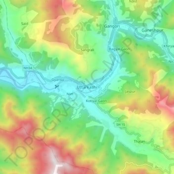
Naam: Topografische kaart Uttarkashi, hoogte, reliëf.
Gemiddelde hoogte: 1.619 m
Minimale hoogte: 1.052 m
Maximale hoogte: 2.642 m
It is the district headquarters of Uttarkashi district. Uttarkashi is situated on the banks of river Bhagirathi at an altitude of 1158 m above sea level. Uttarkashi is generally known as a holy town close to Rishikesh. It is located in the state of Uttarakhand in India. Uttarkashi is home to a number of ashrams and temples and also to the Nehru Institute of Mountaineering. The name of the town reflects its similarity to and location (as north of) the city of Kashi (Varanasi). Similar to Varanasi, town of Uttarkashi is situated on the Ganges, lies next to a hill named Varunavat, on confluence of two rivers Varuna and Asi, has a ghat called Manikarnika Ghat and has a temple dedicated to Shiva similar to (Kashi Vishwanath Temple) in Varanasi, in the center of the town.
Andere topografische kaarten
Klik op een kaart om zijn topografie, zijn hoogte en zijn reliëf te bekijken.
Gangotri Glacier
India > Uttarakhand > Bhatwari
Gangotri Glacier, Bhatwari, Uttarkashi, Uttarakhand, India
Gemiddelde hoogte: 5.259 m
Harsil
India > Uttarakhand > Bhatwari
Harsil, Bhatwari, Uttarkashi district, Uttarakhand, India
Gemiddelde hoogte: 2.761 m
Dharali
India > Uttarakhand > Bhatwari > Dharali
Dharali, Bhatwari, Uttarkashi district, Uttarakhand, India
Gemiddelde hoogte: 2.963 m
Shilla
India > Uttarakhand > Bhatwari
Shilla, Bhatwari, Uttarkashi district, Uttarakhand, India
Gemiddelde hoogte: 2.178 m