
Doe een donatie
Rust jezelf uit voor je volgende avontuur:
Als Amazon-partner verdient deze site een commissie op in aanmerking komende aankopen, zonder extra kosten voor jou.
Topografische kaart Jabal Qasiyun
Klik op de kaart om de hoogte weer te geven.
Doe een donatie
Rust jezelf uit voor je volgende avontuur:
Als Amazon-partner verdient deze site een commissie op in aanmerking komende aankopen, zonder extra kosten voor jou.
Jabal Qasiyun
The mountain is also host to an endemic species of iris, Iris damascena, which can be found on the steep eastern slopes, at high elevation. The Syrian government has not given the species any protected status but part of the habitat of the species lies within a military area near the Qassioun Republican Guards Military Base and other military facilities, which prevents civilians from accessing the area. The base and steepness of the habitat also prevent construction or development, but it is still classified as "critically endangered".
Doe een donatie
Rust jezelf uit voor je volgende avontuur:
Als Amazon-partner verdient deze site een commissie op in aanmerking komende aankopen, zonder extra kosten voor jou.
Over deze kaart
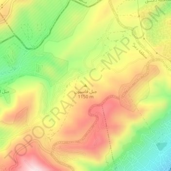
Naam: Topografische kaart Jabal Qasiyun, hoogte, reliëf.
Gemiddelde hoogte: 946 m
Minimale hoogte: 735 m
Maximale hoogte: 1.142 m
Doe een donatie
Rust jezelf uit voor je volgende avontuur:
Als Amazon-partner verdient deze site een commissie op in aanmerking komende aankopen, zonder extra kosten voor jou.